Raw Video Shows Dozens Of People Looting A Dollar Store As Flooding Cuts Wilmington Off From The Rest Of North Carolina

A major emergency brings out the best in some people, but in others it brings out the absolute worst.  Shocking images of “dozens of people” ransacking a Family Dollar store in Wilmington, North Carolina have stunned the nation.  This happened in broad daylight, and many of the looters didn’t even seem to care that a television news crew was filming them.  Sadly, this always seems to happen whenever a major disaster takes place.  Our established social order is so vulnerable, and so many people out there will gladly take advantage of others if they believe that there is an opportunity to get away with it.  If this is how people will behave during a storm, how will they act once things start getting really bad in this country?

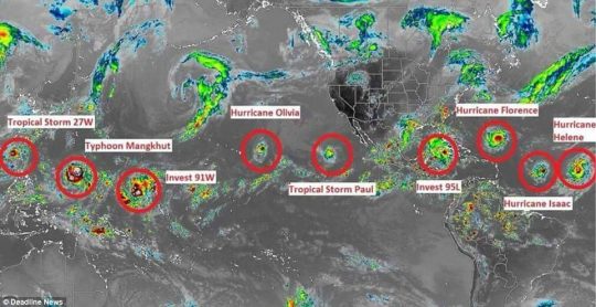
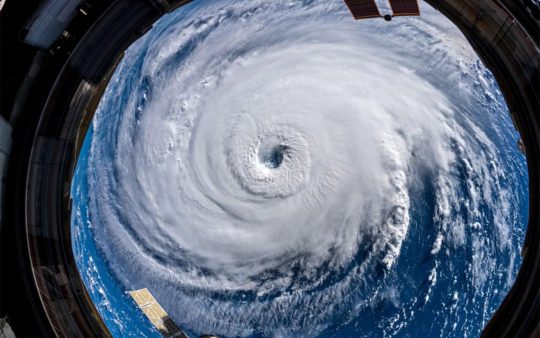
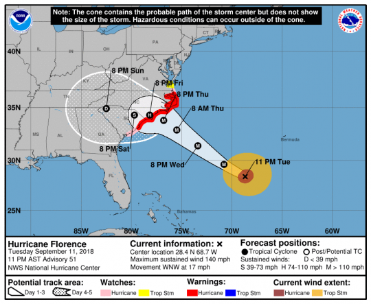
At this hour, Florence continues to dump massive amounts of rain on the Mid-Atlantic region, and now the death toll is up to 18.  It is being reported that more than 640,000 people are without power, and the National Hurricane Center says that more “catastrophic flooding” is coming as Florence remains stationary over the Carolinas.

Major roads all over North Carolina and South Carolina have been flooded, and some parts of Interstate 95 have had to be shut down.

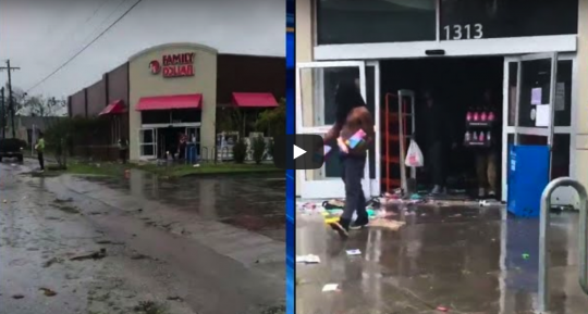
The flooding is already so bad that the city of Wilmington has been completely cut off from the rest of North Carolina, and that is where the Family Dollar store was looted.  One reporter was able to capture raw footage of the looting in progress, and you can see that video on YouTube right here.

This is one of the most disturbing things that I have seen in a long time.

How can people behave like that?

According to one news report, many of the looters were carrying things back to a public housing project right across the street…

Footage from local news station WECT shows dozens of people carrying any items they could get their hands on out of the store and back to a public housing community called Houston Moore.

While there were no members of law enforcement on the scene due to management’s request, police enacted a curfew for the area from 5pm Saturday to 6am Sunday.

They also said many of the alleged looters could be identified in WECT’s video. They encouraged locals to report anyone they recognized in the footage.

If it was just one or two people doing the looting, that would be one thing.

But for “dozens of people” to be looting a store in broad daylight is a very frightening indication as to where we are at as a society.

The storm just arrived a couple days ago, so none of these people were hurting for food or water.  They were just immensely greedy, and they decided to loot the store because they thought they could get away with it.

According to one reporter, “you could just see people everywhere”

WECT reporter Chelsea Donovan, who went to the scene with another journalist to film the looting, said: ‘When we came over the hill on Greenfield Street, you could just see people everywhere.’

In her news coverage Donovan gestures into the store’s front entrance as she says: ‘You can see here inside just a complete mess, people taking duffel bags and trash bags, now noticing we’re here [and] running away from the camera.’

And of course this was not the only instance of criminal activity in the region.

Over in Brunswick County, at least 4 crooks were arrested

Dashaun Smith, 25, and Brandon Bellamy, 30, are both charged with possession of burglary tools and break and or enter at Tommy’s Mini Mart in Leland. They are each being held under a $20,000 bond.

Devin Harris, 21, and Justice Harris, 18, are both charged with break or enter a motor vehicle. They are being held under a $5,000 bond each.

We have raised an entire generation that has no moral foundation, and when things take a turn for the worse in this country we are going to see chaos like this all over America.

It doesn’t matter how many laws you have if people don’t follow them.  To a very large degree, any free society is heavily dependent on the fact that most people will regulate themselves, and that is one of the reasons why the social decay that we see all around us is so deeply alarming.

Ultimately, we will probably see even more looting before this storm is over, because it is being reported that “the worst flooding is yet to come”

Florence’s merciless deluge has already killed 18, trapped hundreds and made parts of North and South Carolina impassable — and authorities say the worst flooding is yet to come.

The tropical depression will keep dumping rain over parts of North Carolina for the next few days, with numerous rivers expected to crest at major flood stage.

Flooding already is so bad in North Carolina that the state transportation department is telling people not to travel in the state. Numerous highways, including sections of I-95 and I-40, are closed, and road flooding has virtually cut off the coastal city of Wilmington.

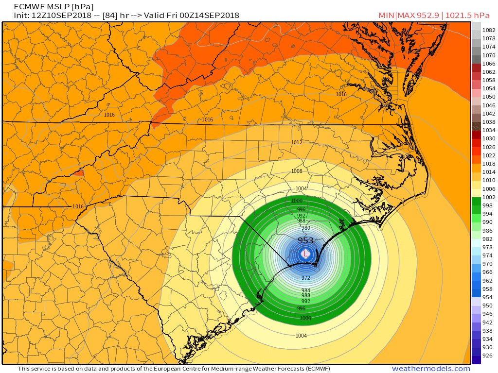
Previously, I have discussed the fact that it is being projected that this storm could potentially dump 10 trillion gallons of water on North Carolina.  The flooding is already “catastrophic”, and you can view some really good before and after photos right here.

The National Hurricane Center says that up to 40 inches of rain will likely fall on southeastern North Carolina and the northeastern tip of South Carolina.  Even though Florence turned out to be not quite as powerful as the experts were anticipating, this is still an extremely, extremely damaging storm.

At times like this, it is so important for communities to come together and support one another.

Unfortunately, some have decided that this is the perfect time for a crime spree, and as an American I am deeply ashamed by what I am seeing.

About the author: Michael Snyder is a nationally syndicated writer, media personality and political activist. He is publisher of The Most Important News and the author of four books including The Beginning Of The End and Living A Life That Really Matters.

A Record 7 Named Storms Are Swirling Across The Globe – Has ‘The Day After Tomorrow’ Arrived?

Is something extremely unusual happening to our planet?  At this moment, Hurricane Florence is just one of seven named storms that are currently circling the globe.  That matches the all-time record, and it looks like that record will be broken very shortly as a couple more storms continue to develop.  Back in 2004, a Hollywood blockbuster entitled “The Day After Tomorrow” depicted a world in which weather patterns had gone mad.  One of the most impressive scenes showed nearly the entire planet covered by hurricane-type storms all at once.  Of course things are not nearly as bad as in that film, but during this hurricane season we have definitely seen a very unusual number of hurricanes and typhoons develop.  As our planet continues to change, could this become “the new normal”?

As I mentioned above there are currently seven named storms that are active, but an eighth is about to join them, and that would break the all-time record

The Hurricane season is causing devastation from the Pacific to the Atlantic as seven active storms are currently swirling across the globe – with high chances an eighth powerful storm will soon develop to break an all-time record.

And actually there is an additional storm that is also developing in the Pacific which could bring the grand total to nine.

Overall, there have been 9 named storms in the Atlantic and 15 names storms in the Pacific since the official start of the hurricane season.

That is not normal.

In fact, one veteran meteorologist has said that he has “NEVER seen so much activity in the tropics”…

Far from being the biggest threat facing the US coastline this hurricane season, Florence will be followed by several other storms that rapidly strengthening in the Atlantic. As one veteran meteorologist remarked, “in my 35 years forecasting the weather on TV, I have NEVER seen so much activity in the tropics all at the same time.”

Meanwhile, the biggest storm on the planet is actually in the Pacific Ocean.

Super Typhoon Mangku is a Category 5 hurricane, and it absolutely dwarfs Hurricane Florence

The devastating force of Hurricane Florence is nothing when compared to the category 5 hurricane sweeping over the Pacific Ocean, Super Typhoon Mangkhu.

With winds close to 180mph, the fierce hurricane is feared to land over a mountainous terrain in the northern Philippines on Friday night, before moving over the South China Sea and potentially impacting Hong Kong and Vietnam.

But let’s not minimize the seriousness of Hurricane Florence.  It is currently approximately the size of the state of Michigan, and even though it has been downgraded forecasters are still predicting that it will bring up to 40 inches of rain in some areas.

One meteorologist ran the numbers, and he determined that if the current forecasts are accurate the state of North Carolina could end up getting ten trillion gallons of rain

Weather.us meteorologist Ryan Maue crunched some numbers and tweeted that North Carolina’s 7-day rainfall forecast by the National Weather Service’s Weather Prediction Center would be like getting “a total of over 10 trillion gallons” of rain from Florence. The math was based on the projected state average of 10.1 inches of rainfall for that time span.

Yes, you read that correctly.

Ten trillion gallons of rain.

Needless to say, all of that water is going to cause an immense amount of damage.

Over in Virginia, a top official is warning that “there could be a number of dams that will fail”

In neighboring Virginia, officials with the state’s Department of Conservation and Recreation have identified some 100 dams they are concerned could be at risk, either because of “spotty inspection records” or because they are still being built.

“If we get 20 inches of rain in a relatively short period of time,” Russ Baxter, the department’s deputy director told the WSJ, “there could be a number of dams that will fail.”

As I write this article, some areas along the coast are already getting hammered.  Atlantic Beach has received more than 12 inches of rain, and other towns are already inundated with water.

It is going to be a long couple of days for those living along the Mid-Atlantic coast, and there were reports of panic among those making last-minute preparations

A rowdy crowd was shown in a Facebook video shared by an employee from the supermarket off Glenn School Road in Durham Tuesday pushing one another and shouting as they hurried around the store to gather their supplies.

Police officers were even spotted making their rounds around the Walmart to ensure the safety of shoppers.

One officer is seen restraining a young boy as another shopper drops several bottles of water.

This is yet another example that shows that you never wait until the last minute to get what you need.

In the end, the damage to property will be in the tens of billions of dollars, but only a handful of people will probably lose their lives.

Now that the storm has been downgraded, some are even booking rooms along the coast so that they can say that they rode the storm out.

For instance, 53-year-old Barry Freed says that he is sticking around so that he can cross this off his “bucket list”

For Barry Freed, 53, riding out a hurricane was a chance to cross something off his “bucket list.”

Armed with a few sodas, some M&Ms, Doritos and a copy of Moby Dick, the Greensboro resident booked an AirBnB at a condo here.

As skies darkened Thursday and winds whipped up at Waterway Lodge, just off the marina near Wrightsville Beach, Freed admitted he wasn’t really prepared.

“I kind of thought of this impulsively,” he said. “It’s kind of a stupid idea.”

Yes, it probably is a stupid idea, but I admire his courage.

This storm will come and go, and the recovery will take an extended period of time.

But the much bigger story is what is happening to our planet on a larger scale.  These storms are increasing in number and intensity, and that should definitely alarm all of us.

About the author: Michael Snyder is a nationally syndicated writer, media personality and political activist. He is publisher of The Most Important News and the author of four books including The Beginning Of The End and Living A Life That Really Matters.

“I’ve Never Seen Anything Like This”: Meteorologists Expect Florence To Stall And Hammer The East Coast “For Days”

The bizarre story of Hurricane Florence just keeps becoming even more strange.  The good news is that meteorologists are telling us that the storm is expected to lose intensity as it approaches the east coast, but the really, really bad news is that it is now being projected that Florence will slow down and finally stall just off the coastline.  In a worst-case scenario, the Carolinas and Georgia could be pounded with wind and rain “for days”, and some areas of North Carolina could end up being buried under nine feet of water.  And even though the peak wind speed of Florence has diminished some, the storm just continues to expand in size.  That means that it will ultimately hit a larger portion of the east coast than originally anticipated, and the overall economic cost will also ultimately be worse than the experts were forecasting.

The word “unprecedented” is being used a lot in conjunction with this storm.  It is behaving in ways that it shouldn’t be, and this “strange stall” along the east coast is absolutely baffling the experts.

While discussing this “stall”, Weather Channel meteorologist Greg Postel stated that he had “never seen anything like this”

The weird saga of Hurricane Florence, which has already carved an unprecedented path across the Atlantic, is forecast to persist with a strange stall and trek along the Southeast coast.

Instead of roaring ashore and quickly heading inland and weakening, as most storms do, Hurricane Florence should instead “stall near the coast and then parallel southwestward toward Georgia,” Weather Channel meteorologist Greg Postel said. “I’ve never seen anything like this.”

And don’t let the fact that Hurricane Florence has been downgraded from a Category 4 storm fool you.  The wind speed may be down a bit, but the storm just keeps getting larger, and on Wednesday it was producing waves that were up to 83 feet tall.

If this storm really does stall off of the Carolina coastline, the devastation will be off the charts.  The following comes from CNN

Florence’s predicted slow southward turn on Friday would mean some coastal areas could get damaging hurricane-force winds for more than 24 hours. “If this blows at 120 mph for four hours, … you lose a shingle every two minutes, and all of the sudden, you’ve lost your whole roof after four hours,” CNN meteorologist Chad Myers said.

In addition to extreme wind damage, we could also see unprecedented rainfall totals and flooding

While it sits and spins, the heavy rain Florence unleashes will lead to “catastrophic” and “life-threatening” flooding in the Carolinas. Widespread reports of 20 to 30 inches of rain are likely, and some spots could see 40 inches.

As if that weren’t enough “isolated tornadoes will become a threat Thursday along the North Carolina coast,” the National Weather Service in Wilmington said.

Could you imagine getting 40 inches of rain in a 24 hour period?

And what will things look like if Hurricane Florence decides to stall for an extended period of time and stay roughly in one place for several days?

We don’t know exactly what the storm will do following the “stall”, but what we do know is that the damage from this storm will be immense.

In fact, one FEMA official is warning that power could be knocked out for many people in the danger area for “weeks”

“This one really scares me,” National Hurricane Center Director Ken Graham told CBS.

“This storm is going to knock out power days into weeks. It’s going to destroy infrastructure. It’s going to destroy homes,” said Jeff Byard, an official at the Federal Emergency Management Agency.

If you live in the path of this storm, hopefully you have evacuated already.

If you haven’t evacuated, hopefully you have stocked up on supplies, because most of the stores have already been completely cleaned out.  At this point, even gasoline is in very short supply

Michelle Stober loaded up valuables on Tuesday at her home on Wrightsville Beach to drive back to her primary residence in Cary, North Carolina. Finding fuel for the journey was tough.

“This morning I drove around for an hour looking for gas in Cary. Everyone was sold out,” she said.

And remember, this is just a temporary emergency.  Eventually this storm will pass and the region will begin to recover.

In the event of an even worse emergency that is more long-term in nature, what will you do when all of the supplies are gone and the stores aren’t going to get anything else for the foreseeable future?

On another note, many have found it very interesting that federal officials held a major exercise in which they simulated a Category 4 hurricane slamming into the Mid-Atlantic region back in late April and early May.  Representatives from 91 different federal departments and agencies took part in this exercise, and the results of the exercise were quite alarming

Just months ago, disaster planners simulated a Category 4 hurricane strike alarmingly similar to the real-world scenario now unfolding on a dangerously vulnerable stretch of the East Coast.

A fictional ‘Hurricane Cora’ barreled into southeast Virginia and up the Chesapeake Bay to strike Washington, D.C., in the narrative created by the Federal Emergency Management Agency and Argonne National Laboratory.

The result was catastrophic damage, which has some experts concerned that Hurricane Florence could produce a disaster comparable to 2005’s Hurricane Katrina and in a part of the country that is famously difficult to evacuate.

It is important to remember that Hurricane Katrina was only a Category 3 hurricane when it finally made landfall.  But it was such a massive storm that it absolutely overwhelmed New Orleans.

We could be facing a similar scenario this time around.  Hurricane Florence may only be a Category 2 or a Category 3 hurricane when it finally makes landfall, but it looks like it is going to do an unprecedented amount of damage.

So please be in prayer for those living along the Mid-Atlantic coast, because this may end up being the worst storm that they have ever experienced.

This article originally appeared on The Economic Collapse Blog.  About the author: Michael Snyder is a nationally syndicated writer, media personality and political activist. He is publisher of The Most Important News and the author of four books including The Beginning Of The End and Living A Life That Really Matters.

People Are “Fighting For Food” As Authorities Warn Florence “Could Produce A Disaster Comparable” To Hurricane Katrina

Hurricane Florence is about to make a “direct hit” on the east coast, and public officials are making one ominous declaration about this storm after another.  Florence is being called “extremely dangerous”, “a monster”, “the worst in 60 years” and “the storm of a lifetime”.  By the end of this week we shall see if this storm lives up to the hype, but at this point it is definitely an immensely powerful storm.  Hurricanes of this magnitude very rarely come this far north, and panic is starting to set in all across the mid-Atlantic region as people realize that this is really happening.  Over a million people are in the process of evacuating, and it is being reported that there is “fighting for food” at the stores that still have some supplies left…

“It was chaotic! Oh my goodness, long lines!” said Fatimah Spivey.

Reilly Norman described it as “a mess in there; it’s wiped out clean.”

The water aisles were especially bare — empty shelf after empty shelf.

“We came around 1 and all the waters were gone,” said Blake Swain. “Now, it’s just people fighting for food.”

Interestingly, federal officials actually conducted a “simulation” that involved a category 4 hurricane hitting the mid-Atlantic region back in late April and early May

Just months ago, disaster planners simulated a Category 4 hurricane strike alarmingly similar to the real-word scenario now unfolding on a dangerously vulnerable stretch of the East Coast.

That “simulation” produced “catastrophic damage” along the east coast, and as a result some experts are now concerned “that Hurricane Florence could produce a disaster comparable to 2005’s Hurricane Katrina“…

A fictional “Hurricane Cora” barreled into southeast Virginia and up the Chesapeake Bay to strike Washington, D.C., in the narrative created by the Federal Emergency Management Agency and Argonne National Laboratory.

The result was catastrophic damage, which has some experts concerned that Hurricane Florence could produce a disaster comparable to 2005’s Hurricane Katrina and in a part of the country that is famously difficult to evacuate.

Let us hope that does not happen, because New Orleans still has not fully recovered from Hurricane Katrina after all this time.

But at this point things look very grim.  The computer models are predicting a storm surge of somewhere around 20 feet and up to 45 inches of rain in some parts of North Carolina.

In addition, it is being projected that the insurance industry could be facing up to 20 billion dollars in losses.

And all of those numbers assume that this will remain a Category 4 storm.  According to CNN, there is still a possibility that Florence “could become close to a Category 5 storm” before it slams into the Carolinas…

As of Tuesday morning, Florence was hurling 130-mph winds. Before it pummels the US coastline, Florence could become close to a Category 5 storm — meaning winds could approach 157 mph.

But even a Category 4 storm would be immensely devastating.

A 20 foot storm surge would cause more damage than the wind or the rain from the hurricane would.  It would essentially be a giant “wall of water” that would “swallow parts of the coast”

“Storm surge has the highest potential to kill the most amount of people,” FEMA Administrator Brock Long said. “It also has the highest potential to cause the most destruction.”

Storm surge is basically a wall of water that could swallow parts of the coast.

“This will have a storm surge in the 20-foot range,” Myers said.

And meteorologists are warning that in a worst-case scenario we could actually see Florence stall along the east coast for an extended period of time.  According to the Weather Underground, this is how that could happen…

The steering currents driving Florence toward the East Coast will collapse on Friday, and models now agree the storm is likely to stall somewhere within 100 miles on either side of the coast, perhaps for one or two days.

The 12Z Tuesday run of the European model introduced a new and very distressing possibility: Florence stalling just offshore of North Carolina near Wilmington for roughly a day, then moving southwestward along and just off the South Carolina coast on Saturday, and finally making landfall close to Savannah, Georgia, on Sunday—all while still a hurricane. This outlandish-seeming prospect gained support from the 18Z run of the GFS model. It painted a very similar picture, with a landfall a bit farther north, near Charleston, on Sunday. The 18Z track from the experimental GFS FV3 model is very similar to the GFS track.

In such a scenario, the damage caused by this storm would be multiplied.

To say that this storm is “dangerous” would be a major understatement.  And let us not forget that there are 12 nuclear power reactors directly in the path of this storm.  If things go bad, they could go really, really bad.

As the storm draws closer to the coast, federal officials are begging people to get prepared…

Federal officials begged residents to put together emergency kits and have a plan on where to go.

“This storm is going to knock out power days into weeks. It’s going to destroy infrastructure. It’s going to destroy homes,” said Jeff Byard, an official at the Federal Emergency Management Agency.

Of course those that have waited until now may find that it is already too late.

Gasoline stations all over the mid-Atlantic are already running out of gas, and store shelves are being “picked clean” of essential supplies…

Long lines formed at service stations, and some started running out of gas as far west as Raleigh, with bright yellow bags, signs or rags placed over the pumps to show they were out of order. Some store shelves were picked clean.

“There’s no water. There’s no juices. There’s no canned goods,” Kristin Harrington said as she shopped at a Walmart in Wilmington.

A “perfect storm” is literally heading for the east coast, and some believe that this could be a metaphor for what is happening to the nation as a whole.

For those of you living in the mid-Atlantic, please get out of the path of this storm, and our prayers are with you.

This article originally appeared on The Economic Collapse Blog.  About the author: Michael Snyder is a nationally syndicated writer, media personality and political activist. He is publisher of The Most Important News and the author of four books including The Beginning Of The End and Living A Life That Really Matters.

Hurricane Florence To Intensify “To Near Category 5 Strength” And There Are 12 Nuclear Power Reactors In The Carolinas

The latest forecast is projecting that Hurricane Florence will strengthen “to near category 5 strength” before it makes landfall in the Carolinas, and it is being called “a serious threat to lives and property”.  It is extremely rare for a hurricane of this intensity to come this far north, and one expert is claiming that Florence “has the potential to be the most destructive hurricane we’ve had in modern history for this region.”  At this time, the government is warning of “a life-threatening storm surge” of up to 20 feet or higher, “life-threatening freshwater flooding”, and “damaging hurricane-force winds”.  But there is another factor that not a lot of people are talking about.  There are 12 nuclear power reactors in the Carolinas, including two that are located right along the coast.

According to Google, there are 7 nuclear power reactors in South Carolina…

South Carolina hosts seven operating nuclear power reactors: Catawba Units 1 & 2, Oconee Units 1, 2 & 3, H. B.

And Google says that there are 5 nuclear power reactors in North Carolina…

North Carolina hosts five operating nuclear power reactors: Brunswick Units 1 & 2, McGuire Units 1 & 2, and Shearon Harris Unit 1. These account for nearly 32% of electricity generation in the state.

It is the two reactors at the Brunswick plant that are of the most concern because they sit right along the coast and they are directly in the projected path of the storm.

The following is what Wikipedia has to say about those reactors…

The Brunswick nuclear power plant, named for Brunswick County, North Carolina, covers 1,200 acres (490 ha). The site is adjacent to the town of Southport, North Carolina, and to wetlands and woodlands, and was opened in 1975.

The site contains two General Electric boiling water reactors, which are cooled by water collected from the Cape Fear River and discharged into the Atlantic Ocean.

In a worst case scenario, could we potentially be facing America’s version of Fukushima?

Hurricane Florence greatly intensified on Monday.  This is an excerpt from the very latest NOAA forecast

1. A life-threatening storm surge is likely along portions of the coastlines of South Carolina, North Carolina, and Virginia, and a Storm Surge Watch will likely be issued for some of these areas by Tuesday morning. All interests from South Carolina into the mid-Atlantic region should ensure they have their hurricane plan in place and follow any advice given by local officials.

2. Life-threatening freshwater flooding is likely from a prolonged and exceptionally heavy rainfall event, which may extend inland over the Carolinas and Mid Atlantic for hundreds of miles as Florence is expected to slow down as it approaches the coast and moves inland.

3. Damaging hurricane-force winds are likely along portions of the coasts of South Carolina and North Carolina, and a Hurricane Watch will likely be issued by Tuesday morning. Damaging winds could also spread well inland into portions of the Carolinas and Virginia.

And according to the National Hurricane Center in Miami, there is definitely a possibility that Hurricane Florence could still strengthen into a category 5 storm

Experts weren’t ready to rule out the possibility that Florence could even make landfall as a Category 5 hurricane, a feat never achieved by any recorded storm in the region. Dennis Feltgen, a spokesperson for the National Hurricane Center in Miami, says that reaching Category 5 is “certainly a possibility.” If Florence doesn’t undergo a phenomenon known as an eyewall replacement cycle, which would weaken the storm, it has a chance of reaching the 157-mph boundary line and making history, Feltgen says.

As I mentioned earlier, it is very rare for a storm of this magnitude to make landfall this far north

Landfalling Category 4 hurricanes are rare in the mainland U.S., with just 24 such landfalls since 1851—an average of one every seven years. (Category 5 landfalls are rarer still, with just three on record). All but three of these 27 landfalls by Cat4s and Cat5s have occurred south of South Carolina’s latitude; thus, Florence will be in very select company if it manages to make landfall at Category 4 strength in North or South Carolina.

We only have a couple of previous storms to go on in order to evaluate how bad the storm surge might be.  Unfortunately, water can pile up to enormous heights in this particular region because the continental shelf “extends out more than 50 miles from shore”

It’s a good thing that landfalls by such strong hurricanes are rare along the South Carolina and North Carolina coast, since this coastline is extremely vulnerable to high storm surges. Two of these three historical Carolina Category 4 hurricanes generated a storm tide of 18 – 20 feet: Hugo of 1989 and Hazel of 1954. The other storm–Gracie of 1959–did not (it hit at low tide, significantly reducing the coastal flooding). The storm tide is the combination of the storm surge and the normal lunar tide, measured in height above sea level. The National Hurricane Center uses the terminology “height above ground level” when discussing the storm tide, meaning the height the surge plus tide gets above the normal high tide mark.

The high vulnerability of this coastline is because the continental shelf extends out more than 50 miles from shore, creating a large region of shallow water less than 150 feet deep just offshore that forces storm surge waters to pile up to staggering heights.

In a worst case scenario, we could be talking about an unprecedented mountain of water slamming into the Carolina coastline.

In fact, it is being projected that if Hurricane Florence becomes a category 5 storm that we could see a storm surge of up to 33 feet

WU’s storm surge inundation maps for the U.S. coast, computed using NOAA’s SLOSH model, tell a frightening story. Depending on where its center makes landfall, a mid-strength Category 4 hurricane with 145 mph winds hitting at high tide, in a worst-case scenario, can generate a storm tide in excess of twenty feet above ground level along the entire coast of South Carolina, and along most of the coast of southern North Carolina from the South Carolina border to Morehead City. Many locations could see a higher surge, of up to 27 feet. And a Category 5 storm is much worse: a theoretical peak storm tide of 33 feet is predicted by the SLOSH model for the Intracoastal Waterway north of Myrtle Beach, South Carolina. These peak surges occur over a 10 – 40 mile stretch of coast where the right eyewall makes landfall.

Let us hope that does not happen, because it is hard to imagine the immense devastation that such a storm surge would cause.

And remember – the two nuclear power reactors right along the coast at the Brunswick facility are directly in the path of this storm.

As news about the intensity of this storm has spread, “panic prepping” has been happening all over the Carolinas.  The following comes from Zero Hedge

With memories of the devastation wrought by Hurricanes Harvey, Irma and Maria still fresh in the minds of US consumers, residents of South and North Carolina are taking zero chances as Hurricane Florence – now a Category 4 storm – barrels toward the eastern seaboard. According to local media reports, store shelves have been cleared of vital supplies like bottled water and food as anxious southerners brace for the worst-case scenario.

Shelves at Wal-Marts in North Carolina and South Carolina had been cleared out by Sunday evening, forcing the stores to frantically restock shelves as residents loaded up on everything from water to plywood to generators, per WGN9. Flashlights and batteries also flew off the shelves.

Of course if people had been prepared ahead of time, they would not have to be scrambling for rapidly disappearing supplies at the stores.

And it is being projected that more than a million people will evacuate from coastal areas by the time that this storm reaches shore…

Hurricane Florence is plowing toward the East Coast as a Category 4 storm with a 500-mile wing span, forcing dire warnings and mandatory evacuations – including the entire coastline of South Carolina and parts of Virginia and North Carolina.

In South Carolina alone, more than 1 million residents and tourists are expected to flee from coastal areas, Gov. Henry McMaster said Monday, vowing that state officials “are not going to gamble” with people’s lives.

This is an extremely dangerous storm, and I strongly urge those that live in the region to play it safe.

You can always replace property, but we only get one chance at this life, and so please do not be reckless with yours.

This article originally appeared on The Economic Collapse Blog.  About the author: Michael Snyder is a nationally syndicated writer, media personality and political activist. He is publisher of The Most Important News and the author of four books including The Beginning Of The End and Living A Life That Really Matters.