A Volcano That Could Completely Cover Mexico City With Volcanic Ash Just Erupted 200 Times In A 24 Hour Period

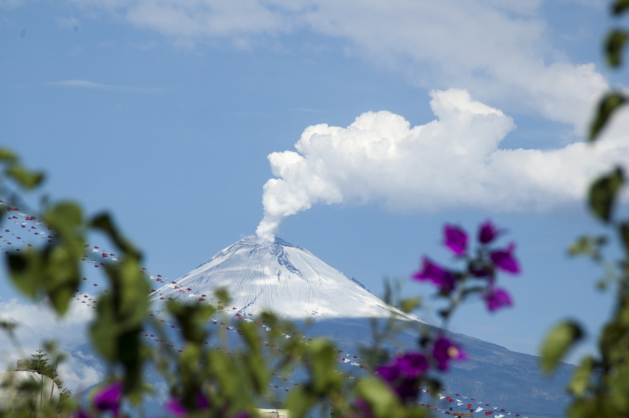
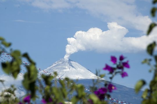
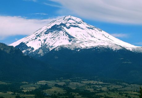
The most dangerous volcano in Mexico just erupted 200 times in a 24 hour period, but there has been an almost total blackout about this in the U.S. media.  Authorities are saying that the odds of more volcanic activity at Mt. Popocatepetl are “immediate to high”, and if a full-blown Plinian eruption were to occur it would be the worst natural disaster in the modern history of North America.  Approximately 26 million people live within 60 miles of Popocatepetl’s crater, and so we are talking about the potential for death and destruction on a scale that is difficult to imagine.  In ancient times, Mt. Popocatepetl buried entire Aztec cities in super-heated mud, but then it went to sleep for about 1,000 years.  Unfortunately for us, it started waking up again in the 1990s, and now this is the most active that we have seen it ever since the volcano originally reawakened.

What we have witnessed over the last several days has been nothing short of stunning.  According to a British news source, a level three yellow alert was put into effect after “200 eruptions were recorded in just 24 hours”…

Popocatépetl volcano, just 35 miles from Mexico City and 20 miles from Puebla sent ash and plumes of smoke more than 1.5 miles high. Mexico’s National Centre for Disaster Prevention (CENAPRED) has warned people to keep away from Popocatépetl after 200 eruptions were recorded in just 24 hours. A level three yellow alert has been issued meaning the chance of volcanic activity is immediate to high.

At this point a 7.5 mile “security radius” has been established around the volcano, and if things continue to get worse authorities will be forced to begin large scale evacuations.

Hopefully there will be enough warning before a Plinian eruption occurs, because several towns could be completely buried by super-heated mud traveling at 60 miles per hour

While not every Plinian-sized eruption is alike in ferocity, all the volcanologists I spoke with provided grave details about Popo’s sure devastation. First, you would see 1,000-degree lahars and pyroclastic flows speeding down at 60 mph. Those flows would reach most, if not all, of the towns in the High Risk area, which today include Santiago Xalitzintla (population: 2,196), and San Pedro Benito Juarez (3,153), and Buenavista (814).

No human on the entire planet can run that fast.  If people are able to get to their vehicles in time they would have a chance, but in reality the highways would quickly become completely clogged as thousands of escaping vehicles all converged at the same time.

Mexico City would be out of range of the tsunami of super-heated mud, but the truth is that the volcanic ash would kill far more people.  Even just breathing in the volcanic ash could potentially be a death sentence

The real threat, of course, begins after the lava halts. If the wind blew in Mexico City’s direction, a city-sized cloud of ash 20 centimeters thick would descend upon the buildings, dismantling roadways, shutting down airports and the Metro line. Breathing it in could kill you. And that’s just the first day. After that, seeping ash would clog Mexico City’s drainage lines, poisoning its water supplies, and ceasing electricity transmission via short-circuiting. With food supplies cut off, and no electricity, the dense metropolis would probably resemble something like the World Trade Center the night of September 11th, except with three times as many people attempting to flee. All under the veil of an ash-blackened sky.

Ultimately, we are talking about an event that would mean the end of the modern nation of Mexico as we know it today, and this is the most active that Mt. Popocatepetl has been in any of our lifetimes.

Are you starting to understand why I get so frustrated with the mainstream media?  What is happening to Mt. Popocatepetl should be front page news all over the county, and yet the mainstream media is almost completely ignoring it.

Meanwhile, a volcano in Washington state is starting to vent steam and gas.

I’ll bet you hadn’t heard about that either.

Mount Baker is 31 miles due east of Bellingham, Washington, and all throughout the month of March steam and gas have been pouring out of the volcano

The state’s quartet of the potentially eruptive peaks are all part of the Cascade Mountain Range, and the northernmost is Mount Baker, which is located in Whatcom County, 31 miles east of Bellingham.

On March 4, the 10,781-foot-tall volcano began producing a number of steam plumes known as fumaroles. The expulsions have continued throughout the month since then and several have been highly visible from many miles away and widely captured in photographs and cell phone videos.

Those of you that are familiar with my work know that I am much more concerned about Mt. Rainier, and when that volcano starts venting steam and gas I am likely to really start freaking out.  But Mount Baker is a very serious threat too because of its “proximity to human population”

Mount Baker last erupted in 1843, but in several recent publications, the U.S. Geological Survey has maintained that Washington state’s third-highest peak continues to present a serious threat due to the frequency of its eruptive history and the volcano’s proximity to human population.

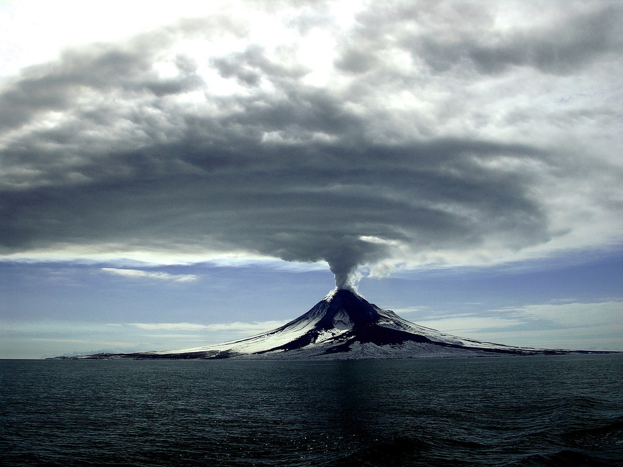
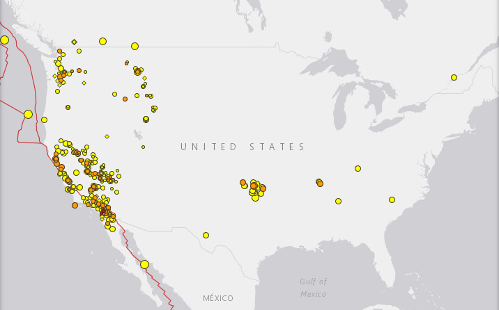
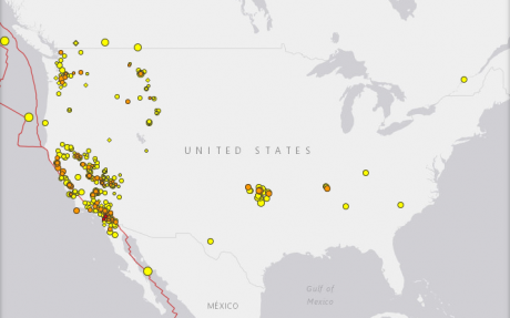
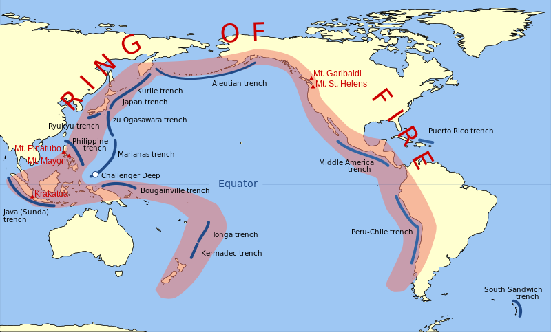
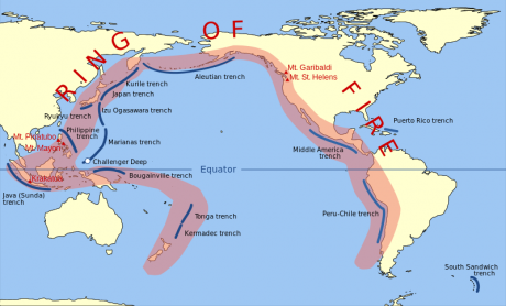
We are seeing a rise in seismic activity all along the Ring of Fire, and as I have frequently warned, North America will not be immune from what is taking place.

The entire west coast lies directly along the Ring of Fire, and seismologists assure us that it is just a matter of time before we witness absolutely massive natural disasters.

And with all of the shaking that is currently going on, the truth is that time may be running out a lot more quickly than many of us had been anticipating…

Get Prepared NowAbout the author: Michael Snyder is a nationally-syndicated writer, media personality and political activist. He is the author of four books including Get Prepared Now, The Beginning Of The End and Living A Life That Really Matters. His articles are originally published on The Economic Collapse Blog, End Of The American Dream and The Most Important News. From there, his articles are republished on dozens of other prominent websites. If you would like to republish his articles, please feel free to do so. The more people that see this information the better, and we need to wake more people up while there is still time.

A Yellow Alert Has Just Been Issued For 2 Major Volcanoes In North America

Massive eruptions of Hawaii’s Kilauea volcano and Guatemala’s Fuego volcano have captivated the entire world in recent days, and now it looks like even more volcanoes are starting to wake up.  In fact, yellow alerts were just issued for Mexico’s Mt. Popocatepetl and Alaska’s Great Sitkin volcano.  Mt. Popocatepetl and Great Sitkin both sit along the “Ring of Fire” that roughly encircles the perimeter of the Pacific Ocean, and many are becoming concerned that we may be witnessing some sort of “chain reaction” as volcanoes all over the globe begin to exhibit signs of increased activity.  This even includes some unusual happenings at Yellowstone, and we will cover that near the end of this article.  But to start with, let’s take a look at the yellow alert that was just issued for Mt. Popocatepetl.  The following comes from a government website in Mexico

In the last 24 hours, through the monitoring systems at Popocatépetl volcano, were registered 30 exhalations with emissions of steam and gas (image 1). At night was possible to observed incandescence that increase with some exhalations (image 2).

At the time of this report the emission are dispersed to the south-southwest direction (image 3).

CENAPRED emphasizes that people SHOULD NOT go near the volcano, especially near the crater, due to the hazard caused by ballistic fragments (image 4) and in case of heavy rains leave the bottoms of ravines by the danger of landslides and debris flows.

The Volcanic Traffic Light Yellow Phase 2.

The scenarios foreseen for this phase are:

1. Explosive activity of low to intermediate level.

2. Ash fall in nearby towns.

3. Possibility of short range pyroclastic flows and mudflows.

Any signs of activity at Mt. Popocatepetl should always be taken very, very seriously.

It is known as the most dangerous volcano in North America for a reason.  Experts tell us that centuries ago this volcano actually “covered entire Aztec cities” with super-heated mud…

Historians tell us that Popocatepetl had a dramatic impact on the ancient Aztecs. Giant mud flows produced by massive eruptions covered entire Aztec cities. In fact, some of these mud flows were so large that they buried entire pyramids in super-heated mud.

But we haven’t witnessed anything like that in any of our lifetimes, so it is hard to even imagine devastation of that magnitude.

In addition to Mexico City’s mammoth population, there are millions of others that live in the surrounding region. Overall, there are about 25 million people that live in the immediate vicinity of Popocatepetl. Thankfully, we haven’t seen a major eruption of the volcano in modern times, but at some point that will change.

In a worst case scenario, Mt. Popocatepetl could absolutely devastate Mexico City, kill countless numbers of people and collapse the Mexican economy overnight.

So let us pray that we don’t see a major eruption there any time soon.

Meanwhile, a yellow alert has also been issued for Alaska’s Great Sitkin volcano.  The following comes from the Alaska Volcano Observatory

AVO/USGS Volcanic Activity Notice

Volcano: Great Sitkin (VNUM #311120)

Current Volcano Alert Level: ADVISORY
Previous Volcano Alert Level: NORMAL

Current Aviation Color Code: YELLOW
Previous Aviation Color Code: GREEN

Issued: Sunday, June 10, 2018, 1:26 PM AKDT
Source: Alaska Volcano Observatory
Notice Number:
Location: N 52 deg 4 min W 176 deg 6 min
Elevation: 5709 ft (1740 m)
Area: Aleutians

Volcanic Activity Summary: Earthquake activity at Great Sitkin Volcano has been elevated over the past five days, and earlier today at 11:39 AKDT (19:39 UTC), a signal that may represent a short-lived steam explosion was detected by seismic data. AVO is thus raising the Aviation Color Code and Alert Level to YELLOW/ADVISORY.

Great Sitkin Volcano is monitored by a five-station seismic network on Great Sitkin Island and with additional seismic stations on the nearby islands of Igitkin, Adak, Kagalaska, and Kanaga. A six-element infrasound array to detect explosions (atmospheric pressure waves) was installed on Adak Island in June, 2017, although it is currently (June 2018) only partly operational. AVO also uses satellite imagery to monitor Great Sitkin Volcano.

Recent Observations:
[Volcanic cloud height] not applicable
[Other volcanic cloud information] Unknown

Remarks: Great Sitkin Volcano is a basaltic andesite volcano that occupies most of the northern half of Great Sitkin Island, a member of the Andreanof Islands group in the central Aleutian Islands. It is located 43 km (26 miles) east of the community of Adak. Great Sitkin erupted at least three times in the 20th century, most recently in 1974. That eruption produced at least one ash cloud that likely exceeded an altitude of 25,000 ft above sea level. A poorly documented eruption occurred in 1945, also producing a lava dome that was partially destroyed in the 1974 eruption. A seismic swarm occurred from July 2016 through the end of 2017.

Unlike  Mt. Popocatepetl, Great Sitkin is located very far away from any large population centers, and so even a full-blown eruption of that volcano would not be that catastrophic.

Of course the same cannot be said about Yellowstone.  As I have written about many times, a full-blown eruption at Yellowstone could potentially change all of our lives in a single moment.  That is why the unusual activity that is happening there right now is such a concern

Yellowstone’s Steamboat Geyser, the largest in the world, has now erupted eight times in less than three months, in a geological puzzle that has fascinated scientists working at the site.

The most recent Steamboat eruption occurred Monday just after 9 a.m. “It was unbelievable,” Jamie Farrell, a geologist at the University of Utah who happened to be at the geyser during the eruption, told Newsweek. He’s seen plenty of other geysers go off—but not Steamboat, which is capable of the largest eruptions of all currently active geysers.

Eruptions of Steamboat do not happen that often.  As Mac Slavo has noted, the last one was in September 2014…

Until this recent series of eruptions, the last time Steamboat blew was in September 2014. Steamboat’s latest eruption was Monday morning when the geyser shot boiling hot water hundreds of feet into the air. Steam billowed from the geyser for hours longer. Steamboat is located in the Norris Geyser Basin, known to have the hottest and most changeable thermal area in nearly 3,500-square-mile wilderness park that sits on a volcanic hot spot called a caldera. That accounts for the geyser’s towering columns of steam (it’s very, very hot underground) but leaves a major fear-provoking question unanswered: Why now, and is it a sign the giant volcano is waking up?

We better hope that Yellowstone is not awakening.  In a previous article, I described what a full-blown eruption of Yellowstone might look like…

Hundreds of cubic miles of ash, rock and lava would be blasted into the atmosphere, and this would likely plunge much of the northern hemisphere into several days of complete darkness. Virtually everything within 100 miles of Yellowstone would be immediately killed, but a much more cruel fate would befall those that live in major cities outside of the immediate blast zone such as Salt Lake City and Denver.

Hot volcanic ash, rock and dust would rain down on those cities literally for weeks. In the end, it would be extremely difficult for anyone living in those communities to survive. In fact, it has been estimated that 90 percent of all people living within 600 miles of Yellowstone would be killed.

Experts project that such an eruption would dump a layer of volcanic ash that is at least 10 feet deep up to 1,000 miles away, and approximately two-thirds of the United States would suddenly become uninhabitable. The volcanic ash would severely contaminate most of our water supplies, and growing food in the middle of the country would become next to impossible.

In other words, it would be the end of our country as we know it today.

Throughout human history, great societies have been taken down by natural disasters, and despite all of our advanced technology we are extremely vulnerable as well.

So the fact that our planet is becoming increasingly unstable is a major concern, and I believe that this is going to have major implications for our future.

Michael Snyder is a nationally syndicated writer, media personality and political activist. He is the author of four books including The Beginning Of The End and Living A Life That Really Matters.

There Have Been 698 Earthquakes In California Within The Past 30 Days

Why is the west coast shaking so violently?  According to the latest data from Earthquake Track, there have been 698 earthquakes in California within the past 30 days.  By the time that you read this article, that number will undoubtedly have changed.  In recent days I have felt such an urgency to write about the seismic activity on the west coast, and I am quite concerned that so few people seem to be paying attention to what is happening.

As I have covered previously, scientists tell us that when seismic activity begins to escalate the probability of having a major earthquake jumps significantly.  Over the past month there have been more mainstream news articles about earthquake swarms in California than I have seen in years, and the magnitude 4.6 earthquake that rattled Monterey County earlier this month made headlines all over the world.

And it isn’t just the U.S. section of the “Ring of Fire” that seems to be awakening.  I have written about Mt. Popocatepetl down in Mexico several times recently, and on Friday it erupted three more times

Spectacular eruptions have been seen Southeast of Mexico City as Mexico’s Popocatepetl volcano spewed smoke and ash high into the air.

The volcano had three eruptions Friday, one of which reached two and a half miles into the sky.

The first explosion occurred at about 5:00 p.m. local time.

Two more explosions overnight spread ash over the villages and fields south of the volcano.

I cannot stress enough how potentially dangerous this situation could become.  In ancient times, Mt. Popocatepetl completely covered entire Aztec cities with massive amounts of super-heated mud.  Scientists assure us that someday Mt. Popocatepetl will once again erupt in a similar fashion, and the devastation that this will cause will be off the charts.

Meanwhile, an extremely dangerous volcano on the other side of the Ring of Fire is also rapidly coming to life.  When Mount Agung violently erupted in 1963, more than a thousand people were killed, and authorities are extremely concerned about the eruptions that are happening right now

Volcanic eruptions on the Indonesian resort island of Bali have prompted officials to cancel flights and move about 24,000 residents out of the way as a thick ash cloud from Mount Agung, thousands of meters high, drifts east and southeast along the archipelago.

Residents were evacuated from 224 points around the island while Lombok International Airport on Pulau Lombok, the island due east of Bali, has closed temporarily, said Ari Ahsan, spokesman for Ngurah Rai International Airport in Bali.

Over the weekend we witnessed eruption after eruption, and the column of ash coming from the volcano is now more than 4 miles high

The first eruption came around 5:30 p.m. local time (4:30 a.m. ET) Saturday, Bali’s Regional Disaster Management Agency said. More eruptions followed and continued into Sunday, with a “medium-pressure eruption” in the early evening that sent ash 2,000 meters into the air, the agency said.
By late Saturday, the volcanic ash plume had reached an altitude of 7,600 meters (4.7 miles), according to Australia’s Bureau of Meteorology.

But what is troubling authorities more than anything else is the fact that magma has been “detected close to the volcano’s surface”

It told people within a 7.5km exclusion zone to “immediately evacuate” in an “orderly and calm manner”

Magma – molten rock – has now been detected close to the volcano’s surface, said officials and volcanologists.

I know that the mainstream media is endlessly obsessed with covering the controversies surrounding President Trump, but to me all of this seismic activity that we are seeing along the Ring of Fire is the biggest news story in the entire world at the moment.

I am convinced that what we are witnessing is quite unusual.  All over the planet “dead volcanoes” are coming back to life, and major fault lines are being hit by a seemingly endless barrage of small to mid-size earthquakes.

Is it possible that all of this shaking is leading up to something?

Stay tuned, because I believe that what we have seen so far is only just the beginning…

Michael Snyder is a Republican candidate for Congress in Idaho’s First Congressional District, and you can learn how you can get involved in the campaign on his official website. His new book entitled “Living A Life That Really Matters” is available in paperback and for the Kindle on Amazon.com.

Popocatepetl Violently Erupts, And Authorities Warn A Bigger Eruption Could Threaten More Than 20 Million People In Mexico City

Mt. Popocatepetl is one of the most important volcanoes on the entire planet, and yet most Americans are not familiar with it.  In ancient Aztec, Popocatepetl means “smoking mountain”, but to the locals the 5,426-meter-high volcano is simply known as “Don Goyo”.  A catastrophic eruption of “Don Goyo” would be a nightmare scenario for the more than 20 million people living in the Mexico City metropolitan area, and that is why authorities are watching Mt. Popocatepetl very closely at the moment.  In fact, we are being warned that the eruption that just took place could be a precursor to an even larger eruption

Chilling footage showing the violent eruption emerged online amid fears there could be more.

A huge plume of smoke blasted three kilometres in to the air from the summit of Popocatepetl after a series explosions over the course of 24 hours.

Surrounding towns were blanketed with ash and debris and authorities are now warning a bigger eruption could threaten the 23.6million inhabitants in the Mexican capital, located just 35 miles (56km) away.

This latest eruption actually resulted in what is known as a “volcanotectonic earthquake”.  Such quakes are caused by the movement of magma, and scientists are very concerned about what that might mean.

“Don Goyo” has been spewing ash regularly since early this month, and at this point local residents are being told to remain indoors

Locals have been warned to avoid outdoor activities and to keep doors and windows shut, and it is not yet clear when they can leave their homes.

It has been emitting ash since the beginning of the month, reports suggest, before a string of explosions.

Of course the activity at Mt. Popocatepetl has been ramping up for quite a while.  Back on September 19th, a magnitude 7.1 earthquake that affected Mexico City also triggered a minor eruption of the volcano.

But minor eruptions can be handled.  What we want to avoid is the kind of catastrophic eruption that has given Popocatepetl legendary status.  In fact, we are told that at one time enormous mud flows from the volcano buried entire Aztec cities

Historians tell us that Popocatepetl had a dramatic impact on the ancient Aztecs. Giant mud flows produced by massive eruptions covered entire Aztec cities. In fact, some of these mud flows were so large that they buried entire pyramids in super-heated mud.

But we haven’t witnessed anything like that in any of our lifetimes, so it is hard to even imagine devastation of that magnitude.

In addition to Mexico City’s mammoth population, there are millions of others that live in the surrounding region. Overall, there are about 25 million people that live in the immediate vicinity of Popocatepetl. Thankfully, we haven’t seen a major eruption of the volcano in modern times, but at some point that will change.

Our planet is becoming increasingly unstable, and the magnitude 7.3 earthquake that just hit Iraq is yet more evidence of this fact.

A catastrophic eruption of Mt. Popocatepetl would be a disaster unlike anything North America has seen in centuries, and it would almost instantly collapse Mexico’s economy.

This isn’t getting a lot of attention from the mainstream media in the United States, but this is a major story.  Great shaking is taking place all along the “Ring of Fire”, and that potentially has dramatic implications for people living all over the globe – including the west coast of the United States.

Michael Snyder is a Republican candidate for Congress in Idaho’s First Congressional District, and you can learn how you can get involved in the campaign on his official website. His new book entitled “Living A Life That Really Matters” is available in paperback and for the Kindle on Amazon.com.

Violent Shaking Along The Ring Of Fire Continues A Progression Of Disasters That Began In September

The Ring Of Fire - Photo from WikipediaHave you noticed that seismic activity along the Ring of Fire appears to be dramatically increasing?  According to Volcano Discovery, 39 volcanoes around the world have recently erupted, and 32 of them are associated with the Ring of Fire.  This includes Mt. Popocatepetl which sits only about 50 miles away from Mexico City’s 18 million inhabitants.  If you are not familiar with the Ring of Fire, it is an area roughly shaped like a horseshoe that runs along the outer perimeter of the Pacific Ocean.  Approximately 90 percent of all earthquakes and approximately 75 percent of all volcanic eruptions occur along the Ring of Fire.  Just within the last 24 hours, we have witnessed a 4.4, a 5.4 and a 5.7 earthquake in Alaska, a 6.8 earthquake in Chile and 20 earthquakes in Indonesia of at least magnitude 4.3.  And as you will see below, this violent shaking along the Ring of Fire seems to continue a progression of major disasters that began back during the month of September.

For whatever reason, our planet suddenly seems to be waking up.  Unfortunately, the west coast of the United States is one of the areas where this is being felt the most.  The little city of San Ramon, California is about 45 miles east of San Francisco, and over the past several weeks it has experienced a record-breaking 583 earthquakes

A total of 583 small earthquakes have shaken San Ramon, California, in the last three weeks or so – more than five times the record set 12 years ago, according to the latest US Geological Survey updates.

“It’s the swarm with the largest number of total earthquakes in San Ramon,” said USGS scientist David Schwartz, who is more concerned about the size of quakes than he is the total number of them. Still, the number tops the previous record set in 2003, when 120 earthquakes hit over 31 days, with the largest clocking in at a magnitude of 4.2.

Could this be a prelude to a major seismic event in California?

We shall see what happens.

Meanwhile, records are being shattered in the middle part of the country as well.

For instance, the state of Oklahoma has already set a brand new yearly record for earthquakes

The state recorded its 587th earthquake of 3.0 magnitude or higher early this week, breaking the previous record of 585. That record was set for all of 2014, meaning that Oklahoma has now had more 3.0 magnitude or higher earthquakes so far in 2015 than it did in all of 2014. So far this year, E&E News reports, Oklahoma’s averaged 2.5 quakes each day, a rate that, if it continues, means the state could see more than 912 earthquakes by the end of this year.

Oklahoma has also experienced 21 4.0 magnitude or greater earthquakes so far this year — an increase over last year, which saw 14.

And just over this past weekend there was a very disturbing series of earthquakes in the state

Starting with a magnitude-4.1 temblor at 5:11 a.m. close to the Oklahoma-Kansas border, the region experienced a series of six earthquakes within a 75-minute period Saturday morning, the U.S. Geological Survey reported on its website.

The largest earthquake Saturday morning was the 4.1, which had an epicenter nine miles northwest of Medford, Okla., 59 miles southwest of Wichita.

That was followed by five more quakes near Medford with magnitudes of 2.5, 2.8, 2.5, 3.1 and 2.9 – the last of which came at 6:24 a.m.

A seventh earthquake – this one a magnitude-4.2 temblor – was recorded at 12:29 p.m., 10 miles north-northwest of Medford.

So why aren’t more Americans alarmed that these records are being broken?

We are seeing things that we have never seen before, and I believe that it will soon get even worse.

And this dramatic increase in seismic activity that we are now seeing appears to fit into a larger pattern of major disasters that we have been witnessing over the past couple of months.

As we approached the end of the summer, all of a sudden massive wildfires erupted all across the western third of the country.  According to the National Interagency Fire Center, the only time in U.S. history when wildfires had burned more acres by the end of October was during the record-setting year of 2006.

In 2015, a lot of these wildfires have really been threatening highly populated areas.  I know, because at one point a major fire came within about 10 miles of my own house.  Since the beginning of August, Barack Obama has made an astounding 25 disaster declarations related to fires, and by the end of September the horrible fires that were threatening key areas of the state of California were making headlines all over the world.

Then as we got to the very end of the month of September, a new kind of disaster began to take center stage.  As I wrote about just recently, the storm that would later became known as Hurricane Joaquin developed into a tropical depression on September 28th.

Even though that hurricane never made landfall in the United States, moisture from that storm caused a tremendous amount of chaos along the east coast.

The governor of South Carolina, Nikki Haley, said that it was the most rain that some areas of her state had witnessed “in a thousand years”, and it is being projected that the economic damage that was done by all of the flooding “will probably be in the billions of dollars”.

Shortly after the flooding in South Carolina, a massive storm dumped an enormous amount of rain on southern California.  Because that area had been experiencing severe drought for so long, all of that rain caused tremendous flooding and massive mudslides.  Rivers of mud literally several feet thick completely stopped traffic along many major roads across the region.  If you got caught in those rivers of mud, you were lucky to get out with your life.  In fact, authorities pulled one dead man out of a vehicle that got completely buried by mud several days after the storms had passed.  It took them that long to finally get to him.

The middle of the country was not spared either.  Hurricane Patricia ended up being one of the strongest hurricanes ever measured, and the remnants of that storm dumped an incredible amount of rain on the state of Texas.  There was so much flooding that a train was literally knocked off the tracks by the water.  And about a week after that there was more flooding in the state that caused at least six deaths.

Overall, it has really been a bad couple of months for major disasters, and this sequence of events seems to have begun during the month of September.

So what should we make of all this?  Please feel free to add your voice to the discussion by posting a comment below…