We Are Seeing Heat And Drought In The Southwest United States Like We Haven’t Seen Since The Dust Bowl Of The 1930s

Despite all of the other crazy news that is happening all around the world, the top headlines on Drudge on Monday evening were all about the record heatwave that is currently pummeling the Southwest.  Of course it is always hot during the summer, but the strange weather that we have been witnessing in recent months is unlike anything that we have seen since the Dust Bowl days of the 1930s.  At this moment, almost the entire Southwest is in some stage of drought.  Agricultural production has been absolutely devastated, major lakes, rivers and streams are rapidly becoming bone dry, and wild horses are dropping dead because they don’t have any water to drink.  In addition, we are starting to see enormous dust storms strike major cities such as Las Vegas and Phoenix, and the extremely dry conditions have already made this one of the worst years for wildfires in U.S. history.  What we are facing is not “apocalyptic” quite yet, but it will be soon if the rain doesn’t start falling.

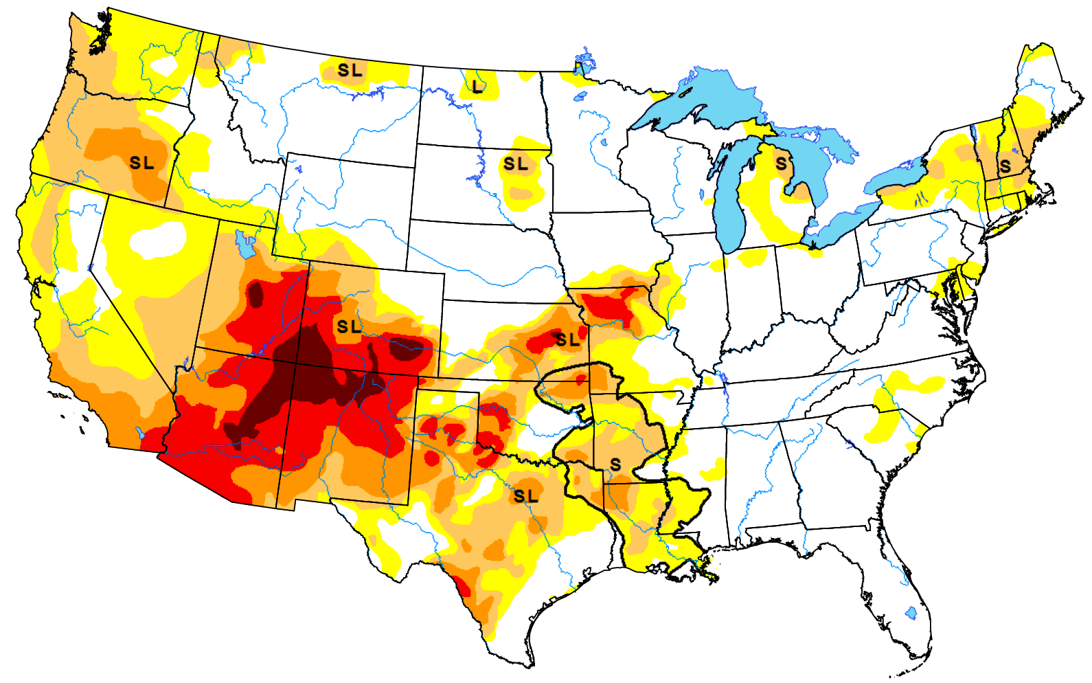
Large portions of Arizona, New Mexico, Colorado and Utah are already at the highest level of drought on the scale.  In Arizona, things are so bad that wild horses have been dropping dead by the dozens, and now authorities are trying to save those that are left

For what they say is the first time, volunteer groups in Arizona and Colorado are hauling thousands of gallons of water and truckloads of food to remote grazing grounds where springs have run dry and vegetation has disappeared.

Federal land managers also have begun emergency roundups in desert areas of Utah and Nevada.

‘We’ve never seen it like this,’ said Simone Netherlands, president of the Arizona-based Salt River Wild Horse Management Group. In May, dozens of horses were found dead on the edge of a dried-up watering hole in northeastern Arizona.

It is being projected that this will be the hottest week of the year so far for much of the Southwest, and on Monday the city of Waco, Texas actually set a brand new all-time record high temperature

Monday was the hottest day on record for Waco as temperatures climbed to 114 degrees just after 5 p.m., according to the National Weather Service.

“Officially and by two degrees, this is the hottest it has ever been in Waco,” National Weather Service meteorologist Dennis Cain said.

Please keep in mind that a record was not just set for that particular date.

114 degrees was the hottest that it has been in the city of Waco ever.

Of course residents of Phoenix are probably scoffing when they read that, because it was even hotter there

Temperatures approached 120 degrees in parts of the U.S. Southwest on Monday, and forecasters said this week could bring the region’s hottest weather of the year.

Phoenix reached a sweltering 115 degrees (46 Celsius), which broke the previous daily record, according to the National Weather Service.

Without air conditioning, Phoenix would not be a viable city.  During this time of the year the air conditioners run extremely hard, and authorities have issued an “excessive heat warning” until Wednesday

From Monday, July 23 to Wednesday, July 25, Phoenix will be under an Excessive Heat Warning. During this time, residents are recommended to stay indoors.

With the temperatures rising and ACs on, APS expects record numbers for energy usage.

Over in California, the big concern is whether the power grid will hold up or not.

On Monday, ISO authorities ordered Californians “to conserve electricity”

California’s power grid operator on Monday issued an alert to homes and businesses to conserve electricity on Tuesday and Wednesday when a heat wave is expected to blanket the state.

The California Independent System Operator (ISO), the grid operator, said it issued the so-called “Flex Alert” due to high temperatures across the western United States, reduced electricity imports into the state, tight natural gas supplies in Southern California and high wildfire risk.

And that followed a similar alert that was put out by Southern California Gas.  It will be very interesting to see if California can get through this current heatwave without any substantial disruptions.

In the past, heatwaves have come and gone, but things are different this time.  Unusual heat has been hammering the Southwest for an extended period of time, and nobody knows when it will end.  For example, experts tell us that the U.S. experienced the hottest month of May ever recorded

The USA is sweltering through what will likely be its hottest May on record, according to a preliminary analysis of weather data.

National Weather Service meteorologist Victor Murphy said May 2018 should break the record set in May 1934 during the Dust Bowl.

Of course it isn’t just the U.S. that is being affected.  Over the past 12 months, we have seen an endless string of record high temperatures being set all over the world.

But what should deeply alarm those of us living in the United States in particular is the return of Dust Bowl conditions to the Southwest.  Just within the past couple of days, we have seen massive dust storms hit Phoenix and Las Vegas.  Very few of us were alive back in the 1930s, but we have heard about the immense devastation that occurred as much of the Southwest was literally transformed into a desert.

Well, now it is happening again.

Scientists tell us that the Southwest has been unusually wet for the past several decades.  For most of human history, the Southwest United States was a bleak, barren desert, and it appears that those conditions may be attempting to return.

If Dust Bowl conditions continue to intensify, it won’t just be Arizona, New Mexico, Colorado and Utah that are affected.  Agricultural production will be devastated in Kansas, Oklahoma, Texas and other Midwest states as well, and that would have profound implications for the U.S. economy and for the future of our society.

Michael Snyder is a nationally syndicated writer, media personality and political activist. He is publisher of The Most Important News and the author of four books including The Beginning Of The End and Living A Life That Really Matters.

The Federal Government Owns 61 Percent Of Idaho, 64 Percent Of Utah And 84 Percent Of Nevada

Did you know that the federal government owns 28 percent of all land in the United States?  Today, the feds control approximately 640 million acres of land, and after decades of very poor management, many are calling on the states to take a larger role.  This is particularly true in the 11 western states where the federal government collectively owns 47 percent of all land.  East of the Mississippi River, the feds only own 4 percent of all land, and there is no reason for such a disparity to exist.  In Connecticut and Iowa, the federal government only owns 0.3 percent of all land.  Such an arrangement seems to work very well for those states, and so why can’t we dramatically reduce federal land ownership in the western states as well?

Of course the federal government will always need a very small amount of land for certain national purposes, and nobody is disputing that.  According to the Heritage Foundation, the following are the primary purposes that federal land is being used for…

These holdings include national parks, national forests, recreation areas, wildlife refuges, vast tracts of range and wasteland managed by the Bureau of Land Management, reservations held in trust for Native American tribes, military bases, and ordinary federal buildings and installations.

We will always need to have some land set aside for those purposes.

But does the Bureau Of Land Management really need more than 247 million acres?

Does the Forest Service really need more than 192 million acres?

Does the Fish and Wildlife Service really need more than 89 million acres?

If the feds were doing a good job, that would be one thing, but in so many instances federal land managers have gotten an extremely bad reputation.  The following comes from an article by Sue Lani Madsen

For example, federal land is exempt from state noxious weed control laws, and lack of weed control has earned federal land a reputation as a bad neighbor. Frustrated local federal land managers are hindered by layers of internal regulations and restricted funding that make timely response to weed outbreaks difficult.

And thanks to mismanagement by the feds, wildfires tend to spread very rapidly in many areas owned and controlled by the federal government.  At this point more than 2.6 million acres of land have already burned in 2017, and that is close to 30 percent ahead of last year’s pace.

If you have never lived in a western state, it may be difficult for you to imagine just how frustrating it is to have the federal government in control of vast stretches of your state.  In so many cases the feds simply do not care about local issues or concerns, and when they drop the ball there is often very little that can be done about it.

According to Ballotpedia, the federal government owns more than 28 percent of the land in 12 different western states…

Washington: 28.5 percent

Montana: 29.0 percent

New Mexico: 34.7 percent

Colorado: 35.9 percent

Arizona: 38.6 percent

California: 45.8 percent

Wyoming: 48.1 percent

Oregon: 52.9 percent

Alaska: 61.2 percent

Idaho: 61.6 percent

Utah: 64.9 percent

Nevada: 84.9 percent

Here in Idaho, we are glad to have so much public land because it is a wonderful thing for hunters, fishers, hikers and those that enjoy other outdoor activities.

So we want to continue our tradition of having wide open spaces that are owned by the public – we just want the federal government to hand over the keys and leave.

We believe that Idaho land should be owned by the people of Idaho, and we believe that Idaho’s natural resources should be managed by the people of Idaho.

Those that are against transferring ownership of federal land to the states often argue that it would be too expensive for the states to handle

Paying for wildfire protection alone—it accounts for about half of the U.S. Forest Service’s annual budget of $6.5 billion—would burden Western taxpayers, says the Center for Western Priorities, a conservation group.

States would be forced to raise taxes or sell off iconic national properties to developers or other private investors in order to pay for everything the federal government does now—from complicated tasks like enforcing environmental regulations and maintaining cultural and historic resources to simple ones like putting up road and trail signs.

But one study found that it is actually profitable for states to manage their own public lands.  Here is more from Sue Lani Madsen

A 2015 study by the Property and Environment Research Center, a free-market environmental think tank, consistently found state-managed land provided a return on every dollar spent while federal lands managed by the U.S. Forest Service and Bureau of Land Management cost more to operate than they return in revenue.

At the end of the day, this is just another area where we need to readjust the balance of power between the states and the federal government.  Our founders intended to create a system where the states had much more power than the central government, but instead that has become totally flipped around.

Today, it is almost as if the 10th Amendment does not even exist.  Most of the time the federal government treats state governments as little more than puppets, and very few state governments have the backbone to stand up for themselves.

As conservatives, we need to start standing up against the costly federal mandates that are imposing such a financial burden on our state governments.  We want control of our own laws and our own budgets.

It is also time for the feds to get off the backs of our farmers, our miners, our loggers and our ranchers.  Some of the most abusive federal agencies, such as the EPA, need to be shut down entirely.

And if our local communities do not want to take Islamic refugees from the Middle East, they should not be forced to do so by the federal government.  Here in Idaho, three young Islamic refugees raped a 5-year-old girl, and yet the federal government does not seem to care about our outrage.

Recently, I have been talking to so many people that just want the federal government to leave us alone.  Instead of solving our problems, most of the time the federal government is the problem, and things would be so much better if the feds would just stay out of our business.

West Coast Seismic Alert: 2 Alaskan Volcanoes Erupt As Earthquake Swarms At Mount St. Helens Raise Concerns

Mount St. Helens, Mount Rainier and Mount Hood are all major volcanoes that lie along the infamous “Ring of Fire” that runs down the west coast of the United States, and all of the seismic activity that has been taking place in the region has many concerned about what may happen next.  Earlier this month, I wrote about how 45 earthquakes of magnitude 2.5 or greater hit Alaska in just one 24 hour period.  This week, it is volcanic activity that is raising concerns.  The earthquake swarms at Mount St. Helens are making headlines all over the globe, and on Tuesday two major volcanoes in Alaska suddenly erupted on the exact same day

An eruption at Bogoslof volcano – one of two to erupt in the Aleutian Islands Tuesday – is its first after more than two months of inactivity, causing ash to fall in a nearby community before drifting south over the Pacific Ocean.

The Alaska Volcano Observatory said Tuesday night’s eruption at the volcano about 60 miles west of Unalaska, which began just after 10:30 p.m. and lasted for 73 minutes, sent a plume to an altitude of 34,000 feet.

Overall, 39 volcanoes around the world are either erupting right now or have recently erupted according to Volcano Discovery.

Most of those active volcanoes are along the Ring of Fire.

Fortunately, the U.S. portion of the Ring of Fire has been less active than other areas in recent years.  But experts assure us that will eventually change because seismic tension continues to build.  One example of this is what is happening at Mount St. Helens right now.  According to scientists, the famous volcano is currently going through what is known as a “magma recharge”

Since mid-April, small earthquakes have been cropping up deep beneath Mount St Helens at ‘relatively high rates,’ bringing roughly one tremor every few hours.

In the last 30 days, scientists have located 55 seismic events in the vicinity, and say there may be well over 100 earthquakes linked to the swarm so far.

The activity falls in line with magma recharge thought to be underway since 2008.

Someday it will erupt again, and the geologists that monitor these things are watching the latest developments very carefully

“Mount St. Helens is at normal background levels of activity,” Liz Westby, a geologist with the U.S. Geological Survey–Cascades Volcano Observatory, told ABC News. “But a bit out of the ordinary are several small magnitude earthquake swarms in March to May 2016, November 2016 and April 16 to May 5, 2017. During the April 16 to May 5, 2017, swarm, we detected well over 100 earthquakes, all below a magnitude 1.3.”

Personally, I am much more concerned about Mount Rainier than I am about Mount St. Helens.  Since the last time it erupted in the late 19th century, hundreds of thousands of people have moved into the danger zone around the volcano, and a full-blown eruption now would eclipse any other natural disaster in recorded U.S. history.

Over the last 30 days, there has also been a good bit of seismic activity at Mount Rainier, and much of it has been centered right along the core of the volcano…

Mount Rainier is capable of unleashing a flow of super-heated mud that could literally cover much of the Seattle/Tacoma area.  If you think that I am exaggerating, please see the following excerpt from Wikipedia

Mount Rainier is currently listed as a Decade Volcano, or one of the 16 volcanoes with the greatest likelihood of causing great loss of life and property if eruptive activity resumes.[45] If Mt. Rainier were to erupt as powerfully as Mount St. Helens did in its May 18, 1980 eruption, the effect would be cumulatively greater, because of the far more massive amounts of glacial ice locked on the volcano compared to Mount St. Helens,[37] the vastly more heavily populated areas surrounding Rainier, and the simple fact that Mt Rainier is a much bigger volcano, almost twice the size of St. Helens.[46] Lahars from Rainier pose the most risk to life and property,[47] as many communities lie atop older lahar deposits. According to the United States Geological Survey (USGS), about 150,000 people live on top of old lahar deposits of Rainier.[7] Not only is there much ice atop the volcano, the volcano is also slowly being weakened by hydrothermal activity. According to Geoff Clayton, a geologist with a Washington State Geology firm, RH2 Engineering, a repeat of the Osceola mudflow would destroy Enumclaw, Orting, Kent, Auburn, Puyallup, Sumner and all of Renton.[36] Such a mudflow might also reach down the Duwamish estuary and destroy parts of downtown Seattle, and cause tsunamis in Puget Sound and Lake Washington.[48] Rainier is also capable of producing pyroclastic flows and expelling lava.[48]

I keep warning about the dangers of a future eruption of Mount Rainier, and this is something that is so heavy on my heart that I even included an eruption of the volcano in my novel entitled The Beginning Of The End.  If you live in the Seattle/Tacoma area, you need to have a plan for a very rapid evacuation in the event a major eruption suddenly takes place.

On the other side of the world, scientists are warning that a supervolcano near Naples, Italy is reaching a critical stage.  The following comes from Newsweek

One of the world’s most dangerous supervolcanoes appears to be closer to erupting than we once thought, scientists have warned. Campi Flegrei in southern Italy has been showing signs of reawakening over the past 67 years, and new research indicates the volcano has been building energy throughout this period, increasing the risk that it will erupt.

Campi Flegrei is a huge volcanic field that sits about 9 miles to the west of Naples, a city home to over a million people. It is made up of 24 craters and edifices, and appears as a large depression on the surface of the land.

The volcano last erupted in 1538 after almost a century of pressure building up. But though it lasted over a week, this was a comparably small one—40,000 years ago, it produced a “super-colossal” eruption. This is the second highest measure on the volcanic explosivity index, the first being “mega-colossal,” like those seen at the Yellowstone supervolcano in the U.S. thousands of years ago.

For years I have been documenting how the crust of our planet is becoming increasingly unstable, and at some point a major seismic event is going to dramatically change life in America overnight.

Let us hope that day is delayed for as long as possible, but as certainly as you are reading this article it is coming.

Violent Shaking Along The Ring Of Fire Continues A Progression Of Disasters That Began In September

The Ring Of Fire - Photo from WikipediaHave you noticed that seismic activity along the Ring of Fire appears to be dramatically increasing?  According to Volcano Discovery, 39 volcanoes around the world have recently erupted, and 32 of them are associated with the Ring of Fire.  This includes Mt. Popocatepetl which sits only about 50 miles away from Mexico City’s 18 million inhabitants.  If you are not familiar with the Ring of Fire, it is an area roughly shaped like a horseshoe that runs along the outer perimeter of the Pacific Ocean.  Approximately 90 percent of all earthquakes and approximately 75 percent of all volcanic eruptions occur along the Ring of Fire.  Just within the last 24 hours, we have witnessed a 4.4, a 5.4 and a 5.7 earthquake in Alaska, a 6.8 earthquake in Chile and 20 earthquakes in Indonesia of at least magnitude 4.3.  And as you will see below, this violent shaking along the Ring of Fire seems to continue a progression of major disasters that began back during the month of September.

For whatever reason, our planet suddenly seems to be waking up.  Unfortunately, the west coast of the United States is one of the areas where this is being felt the most.  The little city of San Ramon, California is about 45 miles east of San Francisco, and over the past several weeks it has experienced a record-breaking 583 earthquakes

A total of 583 small earthquakes have shaken San Ramon, California, in the last three weeks or so – more than five times the record set 12 years ago, according to the latest US Geological Survey updates.

“It’s the swarm with the largest number of total earthquakes in San Ramon,” said USGS scientist David Schwartz, who is more concerned about the size of quakes than he is the total number of them. Still, the number tops the previous record set in 2003, when 120 earthquakes hit over 31 days, with the largest clocking in at a magnitude of 4.2.

Could this be a prelude to a major seismic event in California?

We shall see what happens.

Meanwhile, records are being shattered in the middle part of the country as well.

For instance, the state of Oklahoma has already set a brand new yearly record for earthquakes

The state recorded its 587th earthquake of 3.0 magnitude or higher early this week, breaking the previous record of 585. That record was set for all of 2014, meaning that Oklahoma has now had more 3.0 magnitude or higher earthquakes so far in 2015 than it did in all of 2014. So far this year, E&E News reports, Oklahoma’s averaged 2.5 quakes each day, a rate that, if it continues, means the state could see more than 912 earthquakes by the end of this year.

Oklahoma has also experienced 21 4.0 magnitude or greater earthquakes so far this year — an increase over last year, which saw 14.

And just over this past weekend there was a very disturbing series of earthquakes in the state

Starting with a magnitude-4.1 temblor at 5:11 a.m. close to the Oklahoma-Kansas border, the region experienced a series of six earthquakes within a 75-minute period Saturday morning, the U.S. Geological Survey reported on its website.

The largest earthquake Saturday morning was the 4.1, which had an epicenter nine miles northwest of Medford, Okla., 59 miles southwest of Wichita.

That was followed by five more quakes near Medford with magnitudes of 2.5, 2.8, 2.5, 3.1 and 2.9 – the last of which came at 6:24 a.m.

A seventh earthquake – this one a magnitude-4.2 temblor – was recorded at 12:29 p.m., 10 miles north-northwest of Medford.

So why aren’t more Americans alarmed that these records are being broken?

We are seeing things that we have never seen before, and I believe that it will soon get even worse.

And this dramatic increase in seismic activity that we are now seeing appears to fit into a larger pattern of major disasters that we have been witnessing over the past couple of months.

As we approached the end of the summer, all of a sudden massive wildfires erupted all across the western third of the country.  According to the National Interagency Fire Center, the only time in U.S. history when wildfires had burned more acres by the end of October was during the record-setting year of 2006.

In 2015, a lot of these wildfires have really been threatening highly populated areas.  I know, because at one point a major fire came within about 10 miles of my own house.  Since the beginning of August, Barack Obama has made an astounding 25 disaster declarations related to fires, and by the end of September the horrible fires that were threatening key areas of the state of California were making headlines all over the world.

Then as we got to the very end of the month of September, a new kind of disaster began to take center stage.  As I wrote about just recently, the storm that would later became known as Hurricane Joaquin developed into a tropical depression on September 28th.

Even though that hurricane never made landfall in the United States, moisture from that storm caused a tremendous amount of chaos along the east coast.

The governor of South Carolina, Nikki Haley, said that it was the most rain that some areas of her state had witnessed “in a thousand years”, and it is being projected that the economic damage that was done by all of the flooding “will probably be in the billions of dollars”.

Shortly after the flooding in South Carolina, a massive storm dumped an enormous amount of rain on southern California.  Because that area had been experiencing severe drought for so long, all of that rain caused tremendous flooding and massive mudslides.  Rivers of mud literally several feet thick completely stopped traffic along many major roads across the region.  If you got caught in those rivers of mud, you were lucky to get out with your life.  In fact, authorities pulled one dead man out of a vehicle that got completely buried by mud several days after the storms had passed.  It took them that long to finally get to him.

The middle of the country was not spared either.  Hurricane Patricia ended up being one of the strongest hurricanes ever measured, and the remnants of that storm dumped an incredible amount of rain on the state of Texas.  There was so much flooding that a train was literally knocked off the tracks by the water.  And about a week after that there was more flooding in the state that caused at least six deaths.

Overall, it has really been a bad couple of months for major disasters, and this sequence of events seems to have begun during the month of September.

So what should we make of all this?  Please feel free to add your voice to the discussion by posting a comment below…

The Number Of Volcanic Eruptions Is Increasing And That Could Lead To An Extremely Cold Winter

Volcanic Eruption - Public DomainThe number of volcanoes that are erupting continues to rise, and scientists cannot seem to explain why this is happening.  In 2013, we witnessed the most volcanic eruptions worldwide that we have ever seen in a single year, and this increased activity has carried over into 2014.  In recent months, we have seen major volcanoes roar to life in Russia, Peru, Hawaii, Reunion Island, Indonesia, and all over Alaska.  It is highly unusual for so many volcanoes to all be erupting at the same time.  According to Volcano Discovery, a whopping 34 volcanoes are erupting around the globe right now.  This is sending a massive amount of dust and ash into the upper atmosphere, and it may explain why many parts of the planet are experiencing strangely cold weather at the moment.  If this trend continues, we could potentially be facing years of crop failures and widespread famines all over the world.

And what we have witnessed already may just be the beginning.  There are several more very large volcanoes around the globe that scientists are extremely concerned about right now.

For example, just check out what is going on in the Philippines

Mayon Volcano in the province of Albay was placed on “Alert Level 3” on Monday evening, September 15, after showing signs of “relatively high unrest,” the Philippine Institute of Volcanology and Seismology (PHIVOLCS) said.

In a bulletin issued at 10:00 pm, PHIVOLCS observed 39 rockfall events from 5:00 am to 8:00 pm on September 15, symptoms of the build-up of magma at the summit dome. At least 32 low frequency volcanic earthquakes were also recorded, indicating magma intrusion or volcanic gas activity.

PHIVOLCS-DOST raised the alert status of Mayon Volcano from Alert Level 2 to Alert Level 3 which is equivalent to a “Critical Alert” in the agency’s 5-level alert system. This means that the volcano is exhibiting relatively high unrest, magma is at the crater, and that an eruption is possible within weeks.

But of even greater concern is Bardarbunga.  It is the largest volcano system in Iceland, and a major eruption could potentially be absolutely catastrophic

This time the threat of an eruption – potentially even more powerful than the one in 2010 – is posed by Bardarbunga, the biggest of Iceland’s 30 or so volcanic systems. Located roughly at the country’s centre, the volcano’s 10-kilometre caldera lies several hundred metres beneath Vatnajokull, Europe’s largest glacier by volume.

Scientists are taking the latest rumblings seriously: roughly 8000 years ago, after all, the volcanic leviathan let rip with the largest eruption of the past 10,000 years.

“It is very difficult to predict exactly what will happen with an eruption,” says Monash University vulcanologist Professor Ray Cas, who is president of the International Association for Volcanology and Chemistry of the Earth.

Scientists tell us that over the last 10,000 years Bardarbunga has produced “more lava than any other volcano on the planet.”

If we witness a full scale eruption at Bardarbunga, the cancellation of a few thousand flights may be the smallest of our concerns.

The truth is that we might be looking at the coldest winter that any of us have ever seen in the northern hemisphere.

But don’t just take my word for it.  The following is from a British newspaper article entitled “Icelandic volcano could trigger Britain’s coldest winter EVER this year“…

Depending on the force of the explosion, minute particles thrust beyond the earth’s atmosphere can trigger DECADES of chaotic weather patterns.

Tiny pieces of debris act as billions of shields reflecting the sun’s light away from earth meaning winter temperatures could plunge LOWER THAN EVER before while summer will be devoid of sunshine.

The first effect could be a bitterly cold winter to arrive in weeks with thermometers plunging into minus figures and not rising long before next summer.

If this did happen, there is nothing that we could do to change it.

We would just have to deal with it.

This is a kind of “climate change” that everyone can agree on.  It is well known that volcanic eruptions can substantially lower global temperatures.  In fact, some global warming theorists are already blaming increased volcanic activity for why temperatures have not been rising in recent years

“In the last decade, the amount of volcanic aerosol in the stratosphere has increased, so more sunlight is being reflected back into space,” said lead author Benjamin Santer, climate scientist at Laurence Livermore National Laboratory, in a press release. “This has created a natural cooling of the planet and has partly offset the increase in surface and atmospheric temperatures due to human influence.”

But if Bardarbunga fully erupts, we could be looking at something a lot worse than a little “global cooling”.

We could potentially be facing winters that never seem to end.

It has happened before in recorded history many times.  The following list comes from Wikipedia

The effects of volcanic eruptions on recent winters are modest in scale, but historically have been significant.

Most recently, the 1991 explosion of Mount Pinatubo, a stratovolcano in the Philippines, cooled global temperatures for about 2–3 years.

In 1883, the explosion of Krakatoa (Krakatau) created volcanic winter-like conditions. The four years following the explosion were unusually cold, and the winter of 1887-1888 included powerful blizzards.  Record snowfalls were recorded worldwide.

The 1815 eruption of Mount Tambora, a stratovolcano in Indonesia, occasioned mid-summer frosts in New York State and June snowfalls in New England and Newfoundland and Labrador in what came to be known as the “Year Without a Summer” of 1816.

A paper written by Benjamin Franklin in 1783 blamed the unusually cool summer of 1783 on volcanic dust coming from Iceland, where the eruption of Laki volcano had released enormous amounts of sulfur dioxide, resulting in the death of much of the island’s livestock and a catastrophic famine which killed a quarter of the Icelandic population. Northern hemisphere temperatures dropped by about 1 °C in the year following the Laki eruption.

In 1600, the Huaynaputina in Peru erupted. Tree ring studies show that 1601 was cold. Russia had its worst famine in 1601-1603. From 1600 to 1602, Switzerland, Latvia and Estonia had exceptionally cold winters. The wine harvest was late in 1601 in France, and in Peru and Germany, wine production collapsed. Peach trees bloomed late in China, and Lake Suwa in Japan froze early.

The possibility of volcanic eruptions substantially cooling our weather is the biggest “climate threat” that we are facing by far.

Without warm summers and plenty of sunshine, our crops will not succeed.

And global food supplies are already stretched to the limit.  Just this week we learned that one out of every nine people in the world does not have enough food to eat.

What would happen if global food production was cut by 10 or 20 percent for a few years?

So keep an eye on Bardarbunga and the other major volcanoes around the planet that are rumbling right now.

They may just play a major role in our immediate future.