Are the Carolinas about to take a direct hit from Hurricane Dorian? As you will see below, that is what some mainstream media reports appear to indicate, but the truth is much more nuanced than that. Yes, Dorian is definitely heading toward the Carolinas, and without a doubt there is a possibility that it could make landfall along the coast, but there is no guarantee that this will happen. Meteorologists are telling us that Dorian will eventually be pushed out of danger to the north and east, but that may not happen in time to spare many coastal communities in both North and South Carolina. And let there be no mistake – this remains an exceedingly dangerous storm. In fact, in recent hours the storm has regained strength and has become even larger…
Stronger and a little larger, Hurricane Dorian is gradually leaving Florida behind, setting its sights on the coasts of Georgia and the Carolinas. These areas face a triple threat of “destructive winds, flooding rains, and life-threatening storm surges,” according to the National Hurricane Center.
We actually do not know if Dorian will make landfall in the Carolinas at this point, but after reading some mainstream articles you would be tempted to think that is precisely what is going to happen. For example, the following comes from USA Today…
Hurricane Dorian swept past Florida on Wednesday on a collision course with the Carolinas, claiming its first life in the U.S. and promising heavy rains, powerful winds and damaging surge.
That certainly makes it sound like the Carolinas are definitely going to take a direct hit from this storm, right?
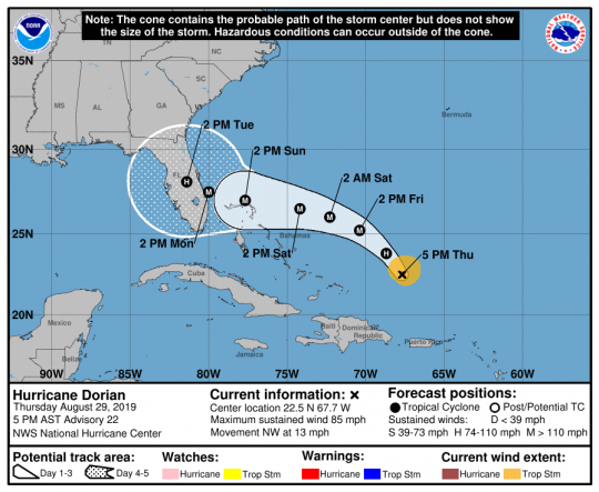
But the latest official forecast makes it very clear that things could go either way. The following comes to us from the NOAA…
At 800 PM EDT (0000 UTC), the large eye of Hurricane Dorian was located near latitude 30.9 North, longitude 79.8 West. Dorian is moving northward near 8 mph (13 km/h). A turn to the north-northeast is anticipated on Thursday, with a turn toward the northeast on Thursday night. A northeastward motion at a faster forward speed is forecast on Friday. On the forecast track, the center of Dorian will continue to approach the coast of South Carolina tonight, move near or over the coast of South Carolina on Thursday, and then move near or over the coast of North Carolina Thursday night and Friday.
But whether this storm officially makes landfall or not, the storm surge that will be created will certainly be immense.
And even though it is no longer a Category 5 storm, Dorian is still capable of “pushing vast amounts of water” because of how absolutely enormous it is…
Now that Dorian is starting to accelerate northward, the storm surge threat to the vulnerable Southeast U.S. coast will increase. Dorian’s enlarged circulation is pushing vast amounts of water, so the surge will be larger than one might assume from Dorian’s decrease from Category 5 to Category 2 strength. Hurricanes such as Ike (2008) and Sandy (2012) produced massively destructive surge long after their peak winds decreased and their circulations expanded.
So those along the Carolina coastline that are not taking this storm seriously are in desperate need of a reality check.
According to Fox News, some of the waves could be up to 37 feet high.
More than a million people along the east coast have been ordered to evacuate, and North Carolina Governor Roy Cooper is strongly urging those in the danger zone to obey those orders…
“Leave now if you are in an area where an evacuation has been ordered,” North Carolina Gov. Roy Cooper urged. “It is not worth putting your life – or the life of first responders – at risk.”
Cooper said an 85-year-old man fell to his death from a ladder while preparing his Columbus County home for the storm. At least 20 deaths in the Bahamas have been linked to Dorian.
In life, timing can be everything, and if you are in the wrong place at the wrong time it can literally cost you your life.
By the beginning of next week communities along the Carolina coastline will be completely out of danger, but over the next couple of days we could potentially see some needless deaths because certain people stubbornly refused to evacuate.
If you don’t believe that the danger is real, perhaps you need to read more about what this storm just did to the Bahamas…
The extent of Dorian’s destruction across the Northern Bahamas is immense. As seen from the air over Abaco Island, the damage stretches for miles.
Entire neighborhoods are flattened, homes shredded, shipping containers and boats hurled inland. Some airports now look more like lakes. The terminal of one airport is now shrouded in debris.
Yes, Dorian is no longer a Category 5 storm, but neither was Hurricane Katrina when it hit New Orleans.
In fact, Hurricane Katrina was only a Category 3 storm when it finally made landfall.
We should be thankful that a “worst case scenario” for this storm never materialized, because what happened to the Bahamas could have very easily happened to us. It was the worst natural disaster that those islands have ever seen, and the recovery process is going to be measured in years.
By Saturday the danger should be gone, but authorities are watching several more potentially dangerous storms right now. Hurricane season does not end until November 30th, and so we are definitely not out of the woods yet.
Global weather patterns have definitely been behaving very strangely all year long, and we could most certainly see even more surprises in the weeks ahead.
 About the author: Michael Snyder is a nationally-syndicated writer, media personality and political activist. He is the author of four books including Get Prepared Now, The Beginning Of The End and Living A Life That Really Matters. His articles are originally published on The Economic Collapse Blog, End Of The American Dream and The Most Important News. From there, his articles are republished on dozens of other prominent websites. If you would like to republish his articles, please feel free to do so. The more people that see this information the better, and we need to wake more people up while there is still time.