West Coast Seismic Alert: 2 Alaskan Volcanoes Erupt As Earthquake Swarms At Mount St. Helens Raise Concerns

Mount St. Helens, Mount Rainier and Mount Hood are all major volcanoes that lie along the infamous “Ring of Fire” that runs down the west coast of the United States, and all of the seismic activity that has been taking place in the region has many concerned about what may happen next.  Earlier this month, I wrote about how 45 earthquakes of magnitude 2.5 or greater hit Alaska in just one 24 hour period.  This week, it is volcanic activity that is raising concerns.  The earthquake swarms at Mount St. Helens are making headlines all over the globe, and on Tuesday two major volcanoes in Alaska suddenly erupted on the exact same day

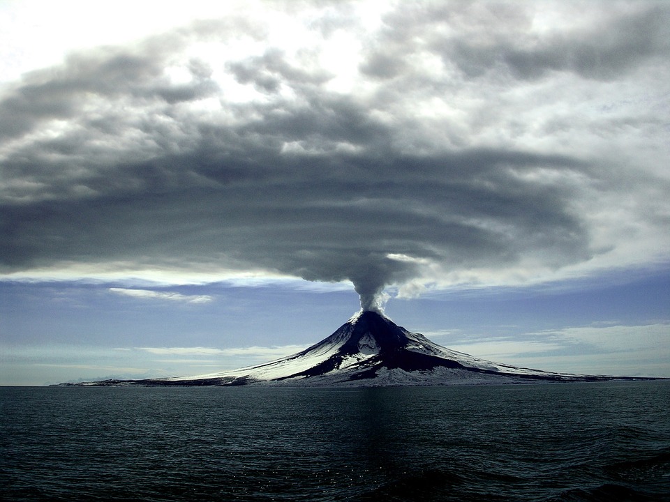
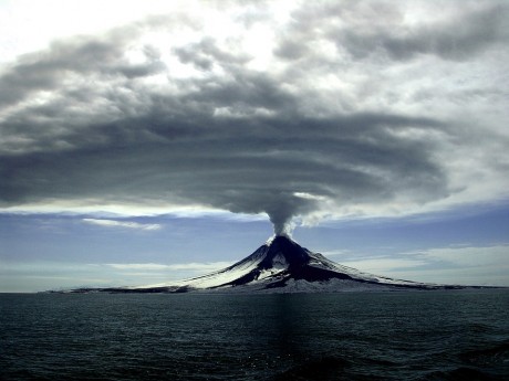
An eruption at Bogoslof volcano – one of two to erupt in the Aleutian Islands Tuesday – is its first after more than two months of inactivity, causing ash to fall in a nearby community before drifting south over the Pacific Ocean.

The Alaska Volcano Observatory said Tuesday night’s eruption at the volcano about 60 miles west of Unalaska, which began just after 10:30 p.m. and lasted for 73 minutes, sent a plume to an altitude of 34,000 feet.

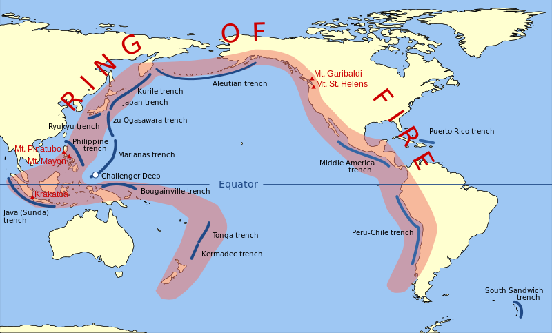
Overall, 39 volcanoes around the world are either erupting right now or have recently erupted according to Volcano Discovery.

Most of those active volcanoes are along the Ring of Fire.

Fortunately, the U.S. portion of the Ring of Fire has been less active than other areas in recent years.  But experts assure us that will eventually change because seismic tension continues to build.  One example of this is what is happening at Mount St. Helens right now.  According to scientists, the famous volcano is currently going through what is known as a “magma recharge”

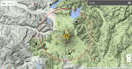
Since mid-April, small earthquakes have been cropping up deep beneath Mount St Helens at ‘relatively high rates,’ bringing roughly one tremor every few hours.

In the last 30 days, scientists have located 55 seismic events in the vicinity, and say there may be well over 100 earthquakes linked to the swarm so far.

The activity falls in line with magma recharge thought to be underway since 2008.

Someday it will erupt again, and the geologists that monitor these things are watching the latest developments very carefully

“Mount St. Helens is at normal background levels of activity,” Liz Westby, a geologist with the U.S. Geological Survey–Cascades Volcano Observatory, told ABC News. “But a bit out of the ordinary are several small magnitude earthquake swarms in March to May 2016, November 2016 and April 16 to May 5, 2017. During the April 16 to May 5, 2017, swarm, we detected well over 100 earthquakes, all below a magnitude 1.3.”

Personally, I am much more concerned about Mount Rainier than I am about Mount St. Helens.  Since the last time it erupted in the late 19th century, hundreds of thousands of people have moved into the danger zone around the volcano, and a full-blown eruption now would eclipse any other natural disaster in recorded U.S. history.

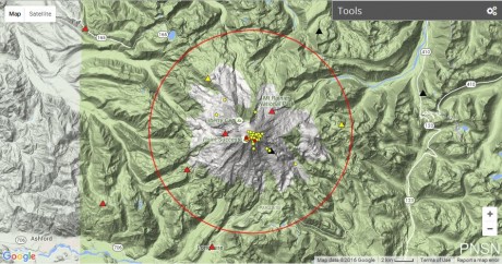
Over the last 30 days, there has also been a good bit of seismic activity at Mount Rainier, and much of it has been centered right along the core of the volcano…

Mount Rainier is capable of unleashing a flow of super-heated mud that could literally cover much of the Seattle/Tacoma area.  If you think that I am exaggerating, please see the following excerpt from Wikipedia

Mount Rainier is currently listed as a Decade Volcano, or one of the 16 volcanoes with the greatest likelihood of causing great loss of life and property if eruptive activity resumes.[45] If Mt. Rainier were to erupt as powerfully as Mount St. Helens did in its May 18, 1980 eruption, the effect would be cumulatively greater, because of the far more massive amounts of glacial ice locked on the volcano compared to Mount St. Helens,[37] the vastly more heavily populated areas surrounding Rainier, and the simple fact that Mt Rainier is a much bigger volcano, almost twice the size of St. Helens.[46] Lahars from Rainier pose the most risk to life and property,[47] as many communities lie atop older lahar deposits. According to the United States Geological Survey (USGS), about 150,000 people live on top of old lahar deposits of Rainier.[7] Not only is there much ice atop the volcano, the volcano is also slowly being weakened by hydrothermal activity. According to Geoff Clayton, a geologist with a Washington State Geology firm, RH2 Engineering, a repeat of the Osceola mudflow would destroy Enumclaw, Orting, Kent, Auburn, Puyallup, Sumner and all of Renton.[36] Such a mudflow might also reach down the Duwamish estuary and destroy parts of downtown Seattle, and cause tsunamis in Puget Sound and Lake Washington.[48] Rainier is also capable of producing pyroclastic flows and expelling lava.[48]

I keep warning about the dangers of a future eruption of Mount Rainier, and this is something that is so heavy on my heart that I even included an eruption of the volcano in my novel entitled The Beginning Of The End.  If you live in the Seattle/Tacoma area, you need to have a plan for a very rapid evacuation in the event a major eruption suddenly takes place.

On the other side of the world, scientists are warning that a supervolcano near Naples, Italy is reaching a critical stage.  The following comes from Newsweek

One of the world’s most dangerous supervolcanoes appears to be closer to erupting than we once thought, scientists have warned. Campi Flegrei in southern Italy has been showing signs of reawakening over the past 67 years, and new research indicates the volcano has been building energy throughout this period, increasing the risk that it will erupt.

Campi Flegrei is a huge volcanic field that sits about 9 miles to the west of Naples, a city home to over a million people. It is made up of 24 craters and edifices, and appears as a large depression on the surface of the land.

The volcano last erupted in 1538 after almost a century of pressure building up. But though it lasted over a week, this was a comparably small one—40,000 years ago, it produced a “super-colossal” eruption. This is the second highest measure on the volcanic explosivity index, the first being “mega-colossal,” like those seen at the Yellowstone supervolcano in the U.S. thousands of years ago.

For years I have been documenting how the crust of our planet is becoming increasingly unstable, and at some point a major seismic event is going to dramatically change life in America overnight.

Let us hope that day is delayed for as long as possible, but as certainly as you are reading this article it is coming.

The Earth’s Crust Will Be Shaken By More Than 100,000 Earthquakes That Humans Can Feel In 2016

Earth From Space 2017 - Public DomainDid you know that our planet will be hit by more than 100,000 earthquakes of magnitude 3.0 or greater this year alone?  Earlier today, I came across a report that contained this amazing fact, but it was so incredible that I felt that I had to go and verify it myself.  So I went to the official USGS website, and I found out that this is actually true.  Overall, there are about half a million earthquakes around the globe each year, but it is only when a quake is of about magnitude 3.0 or greater that humans actually feel them.  As the very large earthquakes in Italy and Myanmar within the last 24 hours have demonstrated, the shaking of our planet is getting worse, and this is something that I have written about over and over again.  So why is this happening?  Why does the crust of our planet seemingly become more and more unstable with each passing year?

We need to start addressing those questions, because there aren’t too many things that can do more damage to a community than a major earthquake.  Very early Wednesday morning, a magnitude 6.2 earthquake struck central Italy.  It is being reported that it sounded “like a bomb” went off, and it looks like this is going to end up being the worst natural disaster to hit Italy in many years.

This earthquake rattled buildings in Rome, it could be felt in Naples to the south, and it is even being claimed that it could be felt all the way up in Bologna in the north.

The epicenter of the quake was a charming little Italian town known as Amatrice.  According to Mayor Sergio Pirozzi, “the town is no more” at this point.  You can see some amazing photographs of the destruction for yourself right here.  Homes, churches and businesses collapsed in heaps of rubble, and at this moment rescuers are engaged in a frantic race against time to pull survivors from the wreckage…

Rescue teams using bulldozers, and aided by townspeople with their bare hands, were still poring through the piles of rock, metal and wood late Wednesday looking for possible survivors. Police near the town of Ascoli said they could hear cries for help from under the rubble but lacked the heavy equipment to move the rocks, according the RAI radio.

“We need chain saws, shears to cut iron bars, and jacks to remove beams: everything, we need everything,” civil protection worker Andrea Gentili told the Associated Press.

So far, the death toll stands at 159 people, but that number is going to go way up as more bodies are discovered.  The following was reported by Reuters

One hotel that collapsed in the small town of Amatrice probably had about 70 guests, and only seven bodies had so far been recovered, said the mayor of the town that was one of the worst hit by the quake.

But as destructive as the Italian quake was, it wasn’t even the largest earthquake on the globe on Wednesday.  A huge magnitude 6.8 earthquake struck Myanmar, but because that earthquake was much deeper it didn’t do the same level of damage as the quake in Italy did…

A powerful earthquake shook Myanmar on Wednesday, killing at least three people and damaging nearly a hundred ancient Buddhist pagodas in the former capital of Bagan, a major tourist site, officials said.

The U.S. Geological Survey said the magnitude 6.8 quake was centered about 25 kilometers (15 miles) west of Chauk, a town south of Bagan. It was located fairly far below the Earth’s surface at a depth of about 84 kilometers (52 miles), it said.

Sadly, most Americans couldn’t care less about what goes on in places like Italy or Myanmar.  I know that may sound terrible, but it is true.

However, Americans should care, because this global rise in earthquake activity is affecting us as well.  In fact, the USGS now says that human activity may at least be partially to blame for the “dramatic increase in seismicity” that we have been witnessing in the United States in recent years…

On Monday, for the first time, the U.S. Geological Survey has released an analysis of the magnitude of “human-induced” earthquakes. That such a thing as human-induced earthquakes can exist is scary enough, but the “dramatic increase in seismicity” in places such as Oklahoma has forced the USGS to consider the threat more broadly.

“By including human-induced events, our assessment of earthquake hazards has significantly increased in parts of the U.S.,” said Mark Petersen, chief of the USGS National Seismic Hazard Mapping Project, in a statement. “This research also shows that much more of the nation faces a significant chance of having damaging earthquakes over the next year, whether natural or human-induced.”

And I wanted to note that there was a magnitude 3.9 earthquake in Colorado on Tuesday.  We have started to see sizable earthquakes in many portions of the country where they are not expected, and this is going to continue to get worse as the shaking of our planet intensifies.

There is one more thing that I wanted to share with you all today.  I don’t know if this is related to anything, but a blood red moon was photographed directly behind the new World Trade Center tower last night.  To some people this is just a meaningless coincidence, but there are others that consider it to be a very ominous sign.

This summer, things have been relatively calm and peaceful in America.  Donald Trump and Hillary Clinton have dominated the headlines, but other than the election there really hasn’t been a major crisis that has grabbed the attention of the nation.

But of course all of that could change in a moment.  Despite all of our advanced technology, the truth is that we are still virtually defenseless against a major natural disaster.

Scientists tell us that it is inevitable that a great New Madrid earthquake will shake the center of the country.  They also tell us that it is inevitable that there will be a major earthquake in southern California, that volcanoes on the west coast will erupt again, and that the Yellowstone supervolcano could wipe out much of the country in a single day.

As global seismic activity continues to rise, it is just a matter of time before a string of historic disasters hits this nation.

Unfortunately, I am convinced that this could happen a lot sooner than most people would dare to imagine.

Southern California Time Bomb: The Ground Surrounding The San Andreas Fault Is ‘Rising And Sinking’

Pacific Plate And The North American PlateIf you reside on the west coast, you are living on borrowed time.  As you will see below, stress has been building up along the San Andreas fault for more than a century, and scientists tell us that southern California is way overdue for a major earthquake.  When that stress is finally released, the U.S. Geological Survey says that we could be looking at hundreds of billions of dollars in damage.  If you follow my work regularly, then you already know that there has been unusual shaking all along the “Ring of Fire” so far in 2016.  But thankfully the west coast of the United States has been spared from a major disaster up to this point.  Unfortunately, scientists assure us that it is only a matter of time before one strikes, and that is why it is so alarming that the ground surrounding the San Andreas fault has been “rising and sinking”.  The following comes from the Los Angeles Times

For the first time, scientists have produced a computer image showing huge sections of California rising and sinking around the San Andreas fault.

The vertical movement is the result of seismic strain that will be ultimately released in a large earthquake.

The California coastline is where two enormous tectonic plates come together.  The Pacific plate and the North American plate are slowly but surely moving against one another, and this creates a tremendous amount of geological stress.  While areas on both sides of the San Andreas fault have been steadily rising and sinking as a result of this stress, there are sections of the fault itself that have remained “locked” for more than 100 years, and other sections that have remained locked for more than 300 years

The region of the San Andreas fault between Monterey County and Imperial County hasn’t moved in a significant way in more than 150 years, and other parts of the fault have been accumulating stress for more than 300 years.

This build up of stress is extremely dangerous, because the more stress that builds up the worse the ultimate release of that stress could turn out to be.

If you look at this map from the U.S. Geological Survey, you can see all of the earthquakes of magnitude 2.5 or greater that have hit California within the past seven days.  As you can see, there has been a whole lot of shaking going on…

California Earthquakes June 2015 - U.S. Geological Survey

And let us not forget that earlier this month a magnitude 5.2 earthquake struck near San Diego, and it was followed by more than 800 aftershocks.

Unfortunately, none of these quakes has relieved the stress along the San Andreas fault.  While the San Andreas fault may be the most famous of the faults in southern California, the truth is that there are many others.  And just last year the U.S. Geological Survey admitted that the probability of a “megaquake” along the west coast involving multiple faults at once was significantly greater than they had previously been projecting

A recent report by the U.S. Geological Survey shows the inevitability of just such a quake, which is predicted to hit within the next couple of decades.

“The new likelihoods are due to the inclusion of possible multi-fault ruptures, where earthquakes are no longer confined to separate, individual faults, but can occasionally rupture multiple faults simultaneously,” lead author of the study and USGS scientist, Ned Field says. “This is a significant advancement in terms of representing a broader range of earthquakes throughout California’s complex fault system.”

But of course the San Andreas fault represents an absolutely massive threat to southern California all by itself.

Back in May, the Los Angeles Times quoted the director of the Southern California Earthquake Center as saying that the San Andreas fault is “locked, loaded and ready to roll”…

“The springs on the San Andreas system have been wound very, very tight. And the southern San Andreas fault, in particular, looks like it’s locked, loaded and ready to go,” Jordan said in the opening keynote talk.

Other sections of the San Andreas fault also are far overdue for a big quake. Further southeast of the Cajon Pass, such as in San Bernardino County, the fault has not moved substantially since an earthquake in 1812, and further southeast toward the Salton Sea, it has been relatively quiet since about 1680 to 1690.

Here’s the problem: Scientists have observed that based on the movement of tectonic plates, with the Pacific plate moving northwest of the North American plate, earthquakes should be relieving about 16 feet of accumulated plate movement every 100 years. Yet the San Andreas has not relieved stress that has been building up for more than a century.

A number of years ago, a study conducted by the U.S. Geological Survey found that just a magnitude 7.8 earthquake along the southern San Andreas fault would cause more than 1,800 deaths, 50,000 injuries and 200 billion dollars in damage.

So what would a magnitude 8 or worse quake do?

And even though the U.S. Geological Survey does not believe that parts of California will eventually fall into the ocean, it is very open about the fact that Los Angeles and San Francisco will one day “be adjacent to one another” as the Pacific plate and the North American plate slowly slip past each other…

Will California eventually fall into the ocean?

No. The San Andreas Fault System, which crosses California from the Salton Sea in the south to Cape Mendocino in the north, is the boundary between the Pacific Plate and North American Plate. The Pacific Plate is moving northwest with respect to the North American Plate at approximately 46 millimeters per year (the rate your fingernails grow). The strike-slip earthquakes on the San Andreas Fault are a result of this plate motion. The plates are moving horizontally past one another, so California is not going to fall into the ocean. However, Los Angeles and San Francisco will one day be adjacent to one another!

Meanwhile, while we are talking about southern California, I just had to mention the record-breaking heatwave and the horrific wildfires that are plaguing the region this week.  In fact, two massive wildfires that have been raging out of control threaten to combine “into one super fire”

Two new fires raging in California could soon merge, creating one ‘super fire’, as wild blazes continue to consume thousands of acres and have already force massive evacuations.

Throughout the United States, firefighters are battling blazes of varying degrees in nine states, including California, New Mexico, Arizona, Alaska, Montana, Washington, Utah, Wyoming and Colorado.

The most serious of these fires have been week-old blazes in California, New Mexico and Arizona, where scorching triple-digit temperatures have stoked the flames.

Normally we don’t see wildfires of this size and intensity until the late summer or early fall.

As I constantly remind my readers, last year was the worst year for wildfires in all of U.S. history, and so far this year we are more than a million acres ahead of the pace that was set last year.

We live at a time when our planet is becoming increasingly unstable.  Earthquakes, volcanic eruptions, wildfires, historic droughts and unusual flooding events all seem to be on the rise globally.

So is there a reason why all of this is happening, or are we just going through a time when we are experiencing an astounding string of truly bizarre coincidences?

Please feel free to tell us what you think by posting a comment below…

*About the author: Michael Snyder is the founder and publisher of The Economic Collapse Blog. Michael’s controversial new book about Bible prophecy entitled “The Rapture Verdict” is available in paperback and for the Kindle on Amazon.com.*

40 Volcanoes Are Erupting Right Now As The Crust Of The Earth Becomes Increasingly Unstable

Volcano Erupting 2 - Public DomainHave you noticed that our planet has begun to shake, rattle and roll?  Over the past few days we have seen major volcanic eruptions in Costa Rica and Indonesia, and according to Volcano Discovery 40 volcanoes around the planet are erupting right now as you read this article.  Meanwhile, earthquakes continue to shake the globe with alarming regularity.  Just last week, Ecuador was hit by a magnitude 6.7 earthquake and a magnitude 6.8 earthquake in rapid succession.  Overall, there have been more than 3,000 earthquakes of magnitude 1.5 or greater within the past month globally.  So yes, I write constantly about the rapidly accelerating deterioration of our financial system, but the coming “collapse” is not just about money.  I am convinced that we are entering a “perfect storm” in which a confluence of factors will absolutely cripple society and bring about changes that most of us would not even dare to imagine right now.

Let’s talk about the volcanic eruptions that we have seen in recent days.  The eruption down in Costa Rica took authorities completely by surprise, and a thick layer of dust and ash is coating vehicles and buildings 30 miles away in the capital city of San Jose

A volcano has erupted in central Costa Rica, belching smoke and ash up to 3,000m (9,840ft) into the air.

Hundreds of people have gone to hospital, complaining of breathing difficulties and skin problems.

Some schools were shut and some flights into the country cancelled or diverted.

People in the capital San Jose, about 45km (30 miles) west of the Turrialba volcano, said layers of ash had coated buildings and cars and there was a fierce smell of sulphur.

Leading up to this eruption, there were “swarms of small earthquakes” in the vicinity of the volcano, but scientists assured the public that these earthquake swarms were “not signs of an imminent eruption.”

Keep that in mind, because later in the article I am going to show you something.

But first let us talk about the other major eruption that is happening right now.  Down in Indonesia, Mount Sinabung has violently erupted, and this is causing all sorts of chaos

The death toll from a volcanic eruption in western Indonesia has climbed to six, an official said Sunday, with fears more could have been trapped by the hot ash.

Three people also remain in a critical condition after Mount Sinabung, a highly-active volcano on Sumatra island, unleashed a series of fresh eruptions on Saturday afternoon, disaster agency spokesman Sutopo Purwo Nugroho said.

“Nine people were struck by the hot clouds. Six died, and three others remain critical with burns,” he said, adding the injured had been taken to hospital.

According to one report, “torrents of lava” are pouring out of the volcano, and this is just one example of how volcanoes that were once considered to be “inactive” are coming to life all over the world.  In fact, prior to 2010 Mount Sinabung had been dormant for about 400 years.

Meanwhile, there is “unprecedented” activity at Iceland’s very dangerous Baroabunga volcano.  This one is not erupting quite yet, but we definitely want to keep an eye on it, because a major eruption there would have serious implications for Europe.

To finish this article, I would like to provide an update to a piece that I posted last week on End of the American Dream.  Just prior to the eruption of the Turrialba volcano in Costa Rica, there were significant earthquake swarms in the vicinity of the volcano.  Well, the exact same thing is happening at three major volcanoes in the United States right now.

I would like to share three images with you that come from Google Earth via the Pacific Northwest Seismic Network.  This first image shows the earthquake activity that has taken place in the area around Mt. St. Helens in recent days.  Over the past month there have been 95 earthquakes in the region, and most of them have been centered right along the core of the volcano…

Mt. St. Helens Today

This next image shows what has been happening at Mt. Rainier.  Those that follow my work closely already know that I consider it to be the most dangerous mountain in America and that I believe that a major eruption of the volcano is coming in the not too distant future.  There have been 36 earthquakes at Mt. Rainier over the past month, and once again most of them have occurred right along the core of the volcano…

Mt. Rainier Today

Mt. Hood is also a very dangerous volcano.  There have been 126 earthquakes in the vicinity of Mt. Hood in recent days, and in this image you can see that the earthquakes have been centered very tightly on a spot on the south face of the mountain.  This is alarming because it was also the south side of Mt. St. Helens that violently erupted back in 1980…

Mt. Hood Today

When there are major volcanic eruptions or major earthquakes in other parts of the globe, many Americans don’t seem to care too much because they don’t think that this rise in global seismic activity is any sort of a threat to them personally.

But the truth is that the entire west coast of the United States lies along the Ring of Fire, and virtually every other section of the Ring of Fire is roaring to life these days.

At some point, there will be historic earthquakes on the west coast.

At some point, there will be historic volcanic eruptions on the west coast.

Scientists assure us that these things are inevitable.

So let us certainly hope for the best, but putting our heads in the sand and pretending that these dangers do not exist is not going to help matters one bit.

Get prepared while you still can, because at some point time will run out.

*About the author: Michael Snyder is the founder and publisher of The Economic Collapse Blog. Michael’s controversial new book about Bible prophecy entitled “The Rapture Verdict” is available in paperback and for the Kindle on Amazon.com.*

Earth Changes In 2016? How To Get Prepared For The Coming Earthquakes And Volcanic Eruptions

Four Horsemen - Public DomainAll over the world seismic activity is increasing.  In recent weeks we have seen a dramatic earthquake in Ecuador, more than 600 earthquakes have experts extremely alarmed about what is happening to Japan’s southern Island, and 37 volcanoes around the planet are erupting right now.  Most of the large earthquakes and volcanic eruptions that we have witnessed lately have come along the Ring of Fire, which is an area of seismic instability which roughly encircles the Pacific Ocean.  Fortunately the west coast of the United States has been spared so far, but scientists tell us that tension has been building up along the San Andreas fault and the Cascadia Subduction Zone for decades, and they assure us that it is only a matter of time before we see a major event.  What that day arrives, will you be prepared?

There were a couple of notable seismic events which took place on Monday.  First of all, the largest volcano in Russia’s Far East known as Klyuchevskaya Sopka violently erupted.  Steaming hot ash was shot more than three miles up into the air, but fortunately it is not a heavily populated area.  This represents yet another major volcanic eruption along the Ring of Fire, and this has some scientists extremely concerned about what may be coming next.

Here in the United States, an unusual swarm of 21 earthquakes along the Arizona-Nevada border is also raising eyebrows

More small earthquakes shook northwest Arizona Sunday adding to the list of temblors that have struck the area since March 29.

The Arizona Geological Survey said two quakes occurred, including a magnitude 2.6 quake at 12:07 a.m.

There has been a swarm of 21 quakes in an area along the Arizona-Nevada line south-southwest of Littlefield, AZ, which is also close to southwestern Utah and the frequency and span puzzles geologists.

The good news is that we have not had a truly historic earthquake in the U.S. for decades, and there have been no major volcanic eruptions since Mount St. Helens exploded back in 1980.

But scientists assure us that we are living on borrowed time, and there are three extremely dangerous volcanoes in North America that I am keeping a close watch on right now…

#1 Mt. Popocatepetl

Popocatepetl is an Aztec word that can be translated as “smoking mountain”, and more than 25 million people live within range of this extraordinarily dangerous mountain.  Experts tell us that during the time of the Aztecs, entire cities were completely buried in super-heated mud from this volcano.  In fact, the super-heated mud was so deep that it buried entire pyramids.  In the event of a full-blown eruption, Mexico City’s 18 million residents probably wouldn’t be buried in super-heated mud, but it would still be absolutely devastating for Mexico’s largest city.

#2 Mt. Rainier

Mt. Rainier has been dubbed a “time bomb“, “the most dangerous mountain in the United States” and “one of the most dangerous volcanoes in the world” because it sits so close to Seattle, Tacoma and other major cities along the coast of Washington state.  In the event of a full-blown eruption, countless numbers of people would literally be buried alive in a tsunami of super-heated mud.  These tsunamis of super-heated mud are known as “lahars”, and scientists believe that Mt. Rainier is capable of producing lahars that could move at speeds of up to 50 miles per hour.  I am so convinced that an eruption of Mt. Rainier is in our future that I even put one in my novel.

#3 The Yellowstone Supervolcano

Many of us that are a bit older still remember the eruption of Mount St. Helens back in 1980.  Well, scientists tell us that a full-blown eruption of the Yellowstone supervolcano would have up to 2,000 times the power of that eruption.  Salt Lake City would be toast, anything caught outside in Denver would probably be dead in pretty short order, and a layer of volcanic ash at least 10 feet deep would be dumped on everything even up to 1,000 miles away.  Food production in America would be virtually wiped out, and a “volcanic winter” would cool global temperatures by up to 20 degrees for an extended period of time.

In other words, life as we know it would come to an end.

That is why the extremely unusual activity going on at Yellowstone right now is such a concern.  If it decides to blow, world history will make a dramatic turn in a single moment.

So what should we do?

As always, we should never give in to fear.  There are definitely going to be major earthquakes and historic volcanic eruptions in North America, and we are going to have to deal with them.  Doing some common sense things in advance will give you and your family the best chance of calmly and smoothly making it through such a crisis.

Below, I have shared some tips that come directly from the CDC.  This first set of tips suggests things that you and your family can do to get prepared for a major earthquake…

—–

Gather Emergency Supplies

Stock up now on emergency supplies that can be used after an earthquake. These supplies should include a first aid kit, survival kits for the home, automobile, and workplace, and emergency water and food. Store enough supplies to last at least 3 days.

Evacuation Plans

If an earthquake occurs, you may need to evacuate a damaged area afterward. By planning and practicing for evacuation, you will be better prepared to respond appropriately and efficiently to signs of danger or to directions by civil authorities.

  • Take a few minutes with your family to discuss a home evacuation plan. Sketch a floor plan of your home; walk through each room and discuss evacuation details.
  • Plan a second way to exit from each room or area, if possible. If you need special equipment, such as a rope ladder, mark where it is located.
  • Mark where your emergency food, water, first aid kits, and fire extinguishers are located.
  • Mark where the utility switches or valves are located so that they can be turned off, if possible.
  • Indicate the location of your family’s emergency outdoor meeting place.

Establish Priorities

Take time before an earthquake strikes to write an emergency priority list, including:

  • important items to be hand-carried by you
  • other items, in order of importance to you and your family
  • items to be removed by car or truck if one is available
  • things to do if time permits, such as locking doors and windows, turning off the utilities, etc.

Write Down Important Information

Make a list of important information and put it in a secure location. Include on your list:

  • important telephone numbers, such as police, fire, paramedics, and medical centers
  • the names, addresses, and telephone numbers of your insurance agents, including policy types and numbers
  • the telephone numbers of the electric, gas, and water companies
  • the names and telephone numbers of neighbors
  • the name and telephone number of your landlord or property manager
  • important medical information, such as allergies, regular medications, etc.
  • the vehicle identification number, year, model, and license number of your automobile, boat, RV, etc.
  • your bank’s or credit union’s telephone number, account types, and numbers
  • radio and television broadcast stations to tune to for emergency broadcast information

Gather and Store Important Documents in a Fire-Proof Safe

  • Birth certificates
  • Ownership certificates (automobiles, boats, etc.)
  • Social Security cards
  • Insurance policies
  • Wills
  • Household inventory, including:
    • list of contents
    • photographs of contents of every room
    • photographs of items of high value, such as jewelry, paintings, collectors’ item

—–

Preparing for a volcanic eruption requires a strategy that is a little bit different.  Here are more tips from the CDC

—–

If you are told to evacuate

Follow authorities’ instructions if they tell you to leave the area. Though it may seem safe to stay at home and wait out an eruption, doing so could be very dangerous. Volcanoes spew hot, dangerous gases, ash, lava, and rock that are powerfully destructive.

Preparing to evacuate

  • Tune in the radio or television for volcano updates.
  • Listen for disaster sirens and warning signals.
  • Review your emergency plan and gather your emergency supplies. Be sure to pack at least a 1-week supply of prescription medications.
  • Prepare an emergency kit for your vehicle with food, flares, booster cables, maps, tools, a first aid kit, a fire extinguisher, sleeping bags, a flashlight, batteries, etc.
  • Fill your vehicle’s gas tank.
  • If no vehicle is available, make arrangements with friends or family for transportation, or follow authorities’ instructions on where to obtain transportation.
  • Place vehicles under cover, if at all possible.
  • Put livestock in an enclosed area. Plan ahead to take pets with you, but be aware that many emergency shelters cannot accept animals.
  • Fill your clean water containers.
  • Fill sinks and bathtubs with water as an extra supply for washing.
  • Adjust the thermostat on refrigerators and freezers to the coolest possible temperature. If the power goes out, food will stay cooler longer.

As you evacuate

  • Take only essential items with you, including at least a 1-week supply of prescription medications.
  • If you have time, turn off the gas, electricity, and water.
  • Disconnect appliances to reduce the likelihood of electrical shock when power is restored.
  • Make sure your automobile’s emergency kit is ready.
  • Follow designated evacuation routes—others may be blocked—and expect heavy traffic and delays.

If you are told to take shelter where you are

  • Keep listening to your radio or television until you are told all is safe or you are told to evacuate. Local authorities may evacuate specific areas at greatest risk in your community.
  • Close and lock all windows and outside doors.
  • Turn off all heating and air conditioning systems and fans.
  • Close the fireplace damper.
  • Organize your emergency supplies and make sure household members know where the supplies are.
  • Make sure the radio is working.
  • Go to an interior room without windows that is above ground level.
  • Bring your pets with you, and be sure to bring additional food and water supplies for them.
  • It is ideal to have a hard-wired (non-portable) telephone in the room you select. Call your emergency contact—a friend or family member who does not live near the volcano—and have the phone available if you need to report a life-threatening condition. Remember that telephone equipment may be overwhelmed or damaged during an emergency.

—–

In the end, you have got to do what you feel is best for you and your family.

Personally, I would be extremely hesitant to live in very high risk areas along the west coast or near the Yellowstone supervolcano.  This is especially true considering how dramatically global seismic activity is increasing.

But others point to the fact that these “danger areas” have not seen any major events in decades, so they wonder what all of the fuss is about.

So what do you think?  Please feel free to join the discussion by posting a comment below…

*About the author: Michael Snyder is the founder and publisher of The Economic Collapse Blog. Michael’s controversial new book about Bible prophecy entitled “The Rapture Verdict” is available in paperback and for the Kindle on Amazon.com.*

Dozens Of Large Earthquakes Strike As Speculation Mounts That Japan’s Southern Island May Split

Kyushu EarthquakesOver the past 48 hours, our planet has been hit by literally dozens of earthquakes of magnitude 4.0 or greater, and scientists are acknowledging that what is taking place is highly unusual.  This strange shaking began toward the end of last week when the globe was struck by five major earthquakes over the space of just two days, and over the weekend the seismic activity just continued to escalate.  Very early on Saturday, Japan’s southern island of Kyushu was hit by a magnitude 7.3 earthquake, and on Saturday night a magnitude 7.8 earthquake struck off Ecuador’s Pacific coast.  It was the worst earthquake that Ecuador had experienced since 1979, and it was followed by at least 163 aftershocks.  Unfortunately, there are indications that what we have seen so far may be just the beginning.

Because the Ecuador earthquake was bigger, it is getting most of the headlines at the moment, but the truth is that what is going on in Japan is potentially far more dangerous.

Over the past week, Japan’s southern Island of Kyushu has been rocked by a series of devastating quakes, including two major ones in less than 48 hours.  The following comes from the Guardian

A second major earthquake in less than two days has shaken Japan’s southern island of Kyushu, with at least 34 people thought to have been killed, about 1,500 injured and more feared buried after building collapses and landslides.

The 7.3 magnitude earthquake struck at about 1.30am on Saturday, waking people across the island – including the thousands already in crisis centres. It caused widespread damage, with several landslides and a village evacuated over fears a dam might burst.

The mainstream media in the United States is using the term “landslides” to describe what has happened all over Kyushu, but the truth is that in many instances it would be far more accurate to say that “giant cracks” or “vast chasms” have formed.  The geography of Japan’s southern island has been fundamentally transformed, and this is beginning to cause huge concerns.  Here is more from the Guardian

One major landslide tore open a mountainside in Minamiaso village in Kumamoto prefecture, destroying a key bridge that could cut off food and other relief transport to the worst-hit area.

Another landslide hit a road, collapsing a house that fell down a ravine. In another part of the village, houses were left hanging precariously at the edge of a huge hole.

I want to show you a map which comes directly from the U.S. Geological Survey.  This map shows all of the earthquakes of magnitude 2.5 or greater that have hit Japan’s southern island over the past week.  As you look at this map, do you see a pattern?…

Kyushu Earthquakes

The dozens of earthquakes that have hit Japan’s southern island over the past week appear to form something of a straight line that divides the island in two.  Many are now speculating that geological forces are beginning to tear Kyushu in half, and if that is true, the earthquake activity that we have seen in Japan so far is probably just the tip of the iceberg.

We could potentially be talking about an event that could ultimately have far more of an impact on Japan than the tsunami of 2011.  By the time it is all said and done, entire cities could be wiped off the map and millions upon millions of Japanese citizens could be displaced.

Already, the seismic activity that has rocked Kyushu is having quite an impact on the Japanese economy

Earlier today Toyota was one of many Japanese companies to announce that it will suspend most car production across Japan as a result of critical supply chain disruptions caused by the recent destructive earthquake and numerous aftershocks. All of the major assembly lines will be shut down across its four directly-run plants, and Toyota will be halting production in stages at other group companies as well.

According to the Nikkei Asian Review, most of the Toyota group in Japan will be effectively shut down through at least the end of this upcoming week, with a production loss of as many as 50,000 vehicles, including brands such as Prius, Lexus, and Land Cruiser.

Our planet resembles something of a giant cracked egg, and the enormous tectonic plates that we are all living on are constantly in motion.  So if Japan’s southern island is in the process of slowly splitting in half, that shouldn’t exactly be a surprise.  After all, scientists assure us that Los Angeles and San Francisco will be directly next to one another someday.

And it isn’t just Japan that we need to be concerned about.  All along the “Ring of Fire”, seismic activity is increasing, and this has many of the experts completely puzzled.  The following comes from an excellent piece by Alvin Conway

This has continued to baffle many of the world’s leading geologists, who still attest the rise in the number of large earthquakes is merely a random natural occurrence. For instance, the number of large earthquakes doubled in 2014. However, here’s what scientists had to say about it: “If you think there have been more earthquakes than usual this year, you’re right. A new study finds there were more than twice as many big earthquakes in the first quarter of 2014 as compared with the average since 1979.

We have recently experienced a period that has had one of the highest rates of great earthquakes ever recorded,” said lead study author Tom Parsons, a research geophysicist with the U.S. Geological Survey (USGS) in Menlo Park, California.

If you are familiar with my work, then you already know that I believe that we have entered a period of time during which we will see seismic activity on a scale that none of us have ever experienced before.

This great shaking will combine with other factors such as financial collapse, geopolitical instability and civil unrest to produce what many have described as a “perfect storm”.  Life as we know it is in the process of fundamentally changing, and right now we are only in the very early chapters of this change.

Unfortunately, most people are ignoring the warnings and will continue to ignore them until it is far too late.

*About the author: Michael Snyder is the founder and publisher of The Economic Collapse Blog. Michael’s controversial new book about Bible prophecy entitled “The Rapture Verdict” is available in paperback and for the Kindle on Amazon.com.*

Violent Shaking Along The Ring Of Fire Continues A Progression Of Disasters That Began In September

The Ring Of Fire - Photo from WikipediaHave you noticed that seismic activity along the Ring of Fire appears to be dramatically increasing?  According to Volcano Discovery, 39 volcanoes around the world have recently erupted, and 32 of them are associated with the Ring of Fire.  This includes Mt. Popocatepetl which sits only about 50 miles away from Mexico City’s 18 million inhabitants.  If you are not familiar with the Ring of Fire, it is an area roughly shaped like a horseshoe that runs along the outer perimeter of the Pacific Ocean.  Approximately 90 percent of all earthquakes and approximately 75 percent of all volcanic eruptions occur along the Ring of Fire.  Just within the last 24 hours, we have witnessed a 4.4, a 5.4 and a 5.7 earthquake in Alaska, a 6.8 earthquake in Chile and 20 earthquakes in Indonesia of at least magnitude 4.3.  And as you will see below, this violent shaking along the Ring of Fire seems to continue a progression of major disasters that began back during the month of September.

For whatever reason, our planet suddenly seems to be waking up.  Unfortunately, the west coast of the United States is one of the areas where this is being felt the most.  The little city of San Ramon, California is about 45 miles east of San Francisco, and over the past several weeks it has experienced a record-breaking 583 earthquakes

A total of 583 small earthquakes have shaken San Ramon, California, in the last three weeks or so – more than five times the record set 12 years ago, according to the latest US Geological Survey updates.

“It’s the swarm with the largest number of total earthquakes in San Ramon,” said USGS scientist David Schwartz, who is more concerned about the size of quakes than he is the total number of them. Still, the number tops the previous record set in 2003, when 120 earthquakes hit over 31 days, with the largest clocking in at a magnitude of 4.2.

Could this be a prelude to a major seismic event in California?

We shall see what happens.

Meanwhile, records are being shattered in the middle part of the country as well.

For instance, the state of Oklahoma has already set a brand new yearly record for earthquakes

The state recorded its 587th earthquake of 3.0 magnitude or higher early this week, breaking the previous record of 585. That record was set for all of 2014, meaning that Oklahoma has now had more 3.0 magnitude or higher earthquakes so far in 2015 than it did in all of 2014. So far this year, E&E News reports, Oklahoma’s averaged 2.5 quakes each day, a rate that, if it continues, means the state could see more than 912 earthquakes by the end of this year.

Oklahoma has also experienced 21 4.0 magnitude or greater earthquakes so far this year — an increase over last year, which saw 14.

And just over this past weekend there was a very disturbing series of earthquakes in the state

Starting with a magnitude-4.1 temblor at 5:11 a.m. close to the Oklahoma-Kansas border, the region experienced a series of six earthquakes within a 75-minute period Saturday morning, the U.S. Geological Survey reported on its website.

The largest earthquake Saturday morning was the 4.1, which had an epicenter nine miles northwest of Medford, Okla., 59 miles southwest of Wichita.

That was followed by five more quakes near Medford with magnitudes of 2.5, 2.8, 2.5, 3.1 and 2.9 – the last of which came at 6:24 a.m.

A seventh earthquake – this one a magnitude-4.2 temblor – was recorded at 12:29 p.m., 10 miles north-northwest of Medford.

So why aren’t more Americans alarmed that these records are being broken?

We are seeing things that we have never seen before, and I believe that it will soon get even worse.

And this dramatic increase in seismic activity that we are now seeing appears to fit into a larger pattern of major disasters that we have been witnessing over the past couple of months.

As we approached the end of the summer, all of a sudden massive wildfires erupted all across the western third of the country.  According to the National Interagency Fire Center, the only time in U.S. history when wildfires had burned more acres by the end of October was during the record-setting year of 2006.

In 2015, a lot of these wildfires have really been threatening highly populated areas.  I know, because at one point a major fire came within about 10 miles of my own house.  Since the beginning of August, Barack Obama has made an astounding 25 disaster declarations related to fires, and by the end of September the horrible fires that were threatening key areas of the state of California were making headlines all over the world.

Then as we got to the very end of the month of September, a new kind of disaster began to take center stage.  As I wrote about just recently, the storm that would later became known as Hurricane Joaquin developed into a tropical depression on September 28th.

Even though that hurricane never made landfall in the United States, moisture from that storm caused a tremendous amount of chaos along the east coast.

The governor of South Carolina, Nikki Haley, said that it was the most rain that some areas of her state had witnessed “in a thousand years”, and it is being projected that the economic damage that was done by all of the flooding “will probably be in the billions of dollars”.

Shortly after the flooding in South Carolina, a massive storm dumped an enormous amount of rain on southern California.  Because that area had been experiencing severe drought for so long, all of that rain caused tremendous flooding and massive mudslides.  Rivers of mud literally several feet thick completely stopped traffic along many major roads across the region.  If you got caught in those rivers of mud, you were lucky to get out with your life.  In fact, authorities pulled one dead man out of a vehicle that got completely buried by mud several days after the storms had passed.  It took them that long to finally get to him.

The middle of the country was not spared either.  Hurricane Patricia ended up being one of the strongest hurricanes ever measured, and the remnants of that storm dumped an incredible amount of rain on the state of Texas.  There was so much flooding that a train was literally knocked off the tracks by the water.  And about a week after that there was more flooding in the state that caused at least six deaths.

Overall, it has really been a bad couple of months for major disasters, and this sequence of events seems to have begun during the month of September.

So what should we make of all this?  Please feel free to add your voice to the discussion by posting a comment below…

40 Volcanoes Are Erupting Right Now, And 34 Of Them Are Along The Ring Of Fire

Volcano Erupting - Public DomainYou may not have noticed, but our planet is becoming increasingly unstable.  According to Volcano Discovery, 40 volcanoes around the globe are erupting right now, and only 6 of them are not along the Ring of Fire.  If that sounds like a very high number to you, that is because it is a very high number.  As I have written about previously, there were a total of 3,542 volcanic eruptions during the entire 20th century.  When you divide that number by 100, that gives you an average of about 35 volcanic eruptions per year.  So the number of volcanoes that are erupting right now is well above the 20th century’s average for an entire calendar year.  And of course we are witnessing a tremendous amount of earthquake activity as well.  Nepal was just hit by the worst earthquake that it had seen in 80 years, and scientists are telling us that the Himalayas actually dropped by an astounding 3 feet as a result of that one earthquake.  How much more does our planet have to shake before people start paying attention?

Of course the things that we have been seeing lately are part of a much larger long-term trend.  Seismic activity appears to have been getting stronger over the past few decades, and now things really seem to be accelerating.  The following is how one news source recently summarized what we have been witnessing…

If it seems like earthquakes and erupting volcanoes are happening more frequently, that’s because they are. Looking at global magnitude six (M6) or greater from 1980 to 1989 there was an average of 108.5 earthquakes per year, from 2000 to 2009 the planet averaged 160.9 earthquakes per year: that is a 38.9% increase of M6+ earthquakes in recent years. Unrest also seems to be growing among the world’s super-volcanoes. Iceland (which is home to some of the most dangerous volcanoes on the planet), Santorini in Greece, Uturuncu in Bolivia, the Yellowstone and Long Valley calderas in the U.S., Laguna del Maule in Chile, Italy’s Campi Flegrei – almost all of the world’s active super-volcanic systems are now exhibiting some signs of inflation, an early indication that pressure is building in these volcanic systems.

But of course most Americans are never going to care about any of this until it starts affecting them personally.

Well, perhaps they should start paying attention to the warning signs.  In recent weeks we have seen significant earthquakes in Michigan, Texas, Mississippi, California, Idaho And Washington.  In addition, it is being reported that pressure is building in dormant volcanoes in Arizona and California.  Just because we have not had a killer earthquake or a large volcanic eruption in the U.S. in recent years does not mean that it will always be that way.  Right now the entire planet appears to be waking up, and this especially seems to be true of the Ring of Fire.

If you are not familiar with the Ring of Fire, just imagine a giant ring that runs around the outer perimeter of the Pacific Ocean.  Approximately 90 percent of all earthquakes and approximately 75 percent of all volcanic eruptions occur within this area, and the entire west coast of North America is considered to be part of the Ring of Fire.

For so long, the west coast has been incredibly blessed not to have experienced a major seismic event.  But scientists tell us that it is only a matter of time.

And right now, just about every other part of the Ring of Fire is shaking violently.

For example, a magnitude 6.8 earthquake just hit Japan on Wednesday

A magnitude-6.8 earthquake that shook northeast Japan on Wednesday was an aftershock of the devastating 2011 quake that triggered a massive tsunami and nuclear power plant meltdown.

“We consider this morning’s earthquake to be an aftershock of the 2011 Northeastern Pacific Earthquake,” said Yohei Hasegawa, an official at the Japanese meteorological agency.

The temblor, which struck just after 6 a.m. local time (5 p.m. ET Tuesday), was sparked by the Pacific tectonic plate “subducting,” or moving under, the main land plate, he added.

Hasegawa warned that more tremors may be on the way.

One Japanese expert is warning that Japan “might have entered an era of great earthquakes and volcanic eruptions“, and considering the immense devastation that the great earthquake and tsunami of 2011 caused, that is a very sobering assessment.

Meanwhile, a series of very strong earthquakes have struck Papua New Guinea recently as well.  The following comes from the Washington Post

A powerful earthquake rattled Papua New Guinea on Thursday, the fourth strong quake to hit the South Pacific island nation in a week. The temblor prompted officials to issue a local tsunami warning, but it was lifted shortly afterward with no reports of damage.

The 7.1-magnitude quake struck about 150 kilometers (94 miles) southwest of the town of Panguna on Bougainville Island at a depth of 23 kilometers (14 miles), the U.S. Geological Survey reported.

Once again, just because things have always been a certain way does not mean that they will always be that way.

As Americans, we are not accustomed to being concerned about major earthquakes and massive volcanic eruptions, but that could soon change in a big way.

The truth is that our planet and our sun are changing in ways that are unpredictable and that our scientists don’t completely understand.

For example, a recent LiveScience article discussed the fact that scientists are deeply puzzled by the fact that the magnetic field of our planet is getting weaker 10 times faster than previously believed…

Scientists already know that magnetic north shifts. Once every few hundred thousand years the magnetic poles flip so that a compass would point south instead of north. While changes in magnetic field strength are part of this normal flipping cycle, data from Swarm have shown the field is starting to weaken faster than in the past. Previously, researchers estimated the field was weakening about 5 percent per century, but the new data revealed the field is actually weakening at 5 percent per decade, or 10 times faster than thought. As such, rather than the full flip occurring in about 2,000 years, as was predicted, the new data suggest it could happen sooner.

And in a previous article, I discussed how one scientist has discovered that activity on the sun is declining at a faster pace “than at any time in the last 9300 years” right now.

I don’t pretend to have all the answers for why these things are happening, but clearly some very unusual things are taking place.

So what do you think?

Do you believe that you know why our planet and our sun are experiencing such dramatic changes?

Please feel free to add to the discussion by posting a comment below…